

 |
|||
The death toll continues to climb from last week’s flooding in Haiti and the Dominican Republic.The U.S. Agency for International Development (USAID) reports that at least 1,068 people are dead, 1,600 are missing, and 25,000 are in need of emergency food and non-food assistance. In the Dominican Republic, 414 are dead and 274 are missing (all from the town of Jimani). The flooding took place on May 24-25, 2004. The worst flooding occurred along a river system that drains the north flank of the Massif de la Salle and in a poorly drained area along the south flank of the massif. This mountain range lies along the southern side of the island of Hispaniola, running east to west. |
Title photo courtesy Corporal Mike Escobar, MCB Camp Lejeune, U.S. Marine Corps |
||
 |
|||
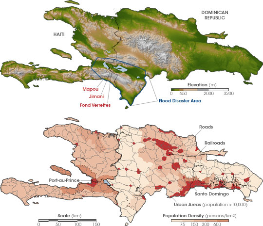
A key factor in the intensity of the destruction is the extensive deforestation within the associated drainage basins and the presence of settlements within the floodplains of rivers and in other low areas on the south flank of the massif. Some of the villages most impacted include Mapou and Fond Verrettes in Haiti, and the town of Jimani across the border in the Dominican Republic. |
These maps compare the topography of Hispaniola (top) with the island’s population density (bottom). The flood disaster area around the Massif de la Salle is outlined in blue. (SRTM image courtesy NASA. Population density map courtesy the SEDAC) |
||
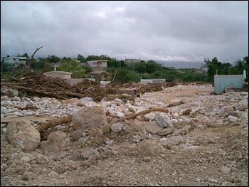 |
Much of the town of Jimani, Dominican Republic, was inundated by the flooding on Hispaniola in May 2004. This photo shows a cemetery in Jimani that was almost completely overrun by gravel and debris deposited by the torrential flows of rainwater running down the northern flank of the Massif de la Salle. (Photo by Manual Santana courtesy USAID) |
||
|
The flooding was driven by intense rainfall. According to the U.S. National Environmental Satellite, Data and Information Service (NOAA), a low-pressure system originating from Central America brought exceptionally heavy showers and thunderstorms to Haiti and the Dominican Republic between May 18-25. Rainfall amounts exceeded 500 mm (19.7 inches) across the border areas of Haiti and the Dominican Republic during this time period. At the town of Jimani, DR, 250 mm (10 inches) of rain fell in just 24 hours, causing the Solie River to overflow its banks May 24-25. NASA Tropical Rainfall Measuring Mission (TRMM) data graphically illustrate the event. The heavy rainfall drove flash flooding and extensive debris flows over extended regions at the base of the Massif de la Salle. Swollen rivers and debris cut off many of the roads traversing the region along the base of the mountain, making it challenging for humanitarian relief workers to rescue stranded people and deliver badly needed food, medicine and supplies to residents. |
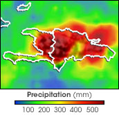
A low-pressure system across the central Caribbean brought heavy rains to the region from May 18-25, 2004. The moist, low-level southerly winds interacted with the topography of Hispaniola to intensify the burst of rain falling on the island. This false-color map shows how much rain fell that week. Dark red shows where more than 500 mm of rain fell. Click to see the movie showing the rainfall over time. (NASA image by Hal Pierce, using data courtesy TRMM Science Team) |
||
 |
 |
|
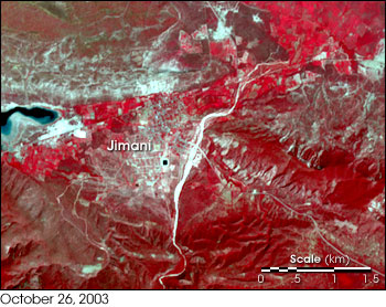
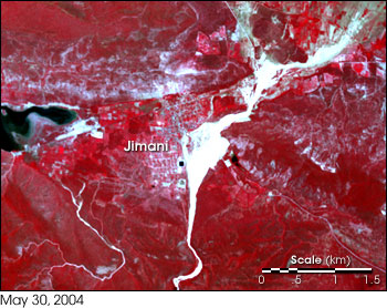
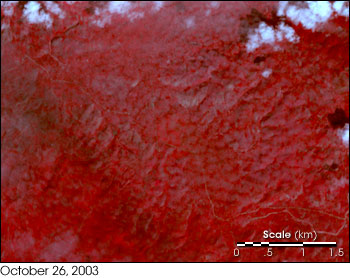
Upon hearing of the disaster, NASA’s Terra satellite team implemented an expedited data request for Advanced Spaceborne Thermal Emission and Reflection Radiometer (ASTER) imagery of the event. (NASA has a protocol for making expedited ASTER data requests for gathering helpful intelligence about natural disaster events.) The Terra ASTER instrument acquired a mostly cloud-free image on May 30, which shows the dramatic extent of the flooding, particularly when compared with an earlier ASTER image acquired on October 26, 2003, during normal conditions. Visual inspection of the ASTER before and after images indicates that debris-carrying flows of floodwater on the north flank of the Massif de la Salle originated as confined discharges within steep-walled channels of bedrock inside canyons. As the floodwaters flowed out onto the relatively flatter lands and broader channels of the alluvial plain below they spread out, wiping out riverside settlements in Haiti and the adjacent part of the Dominican Republic. The resulting deposits of debris appear as light-colored areas along rivers in the ASTER image. Comparison of the imagery with a shaded version of the SRTM data highlights the floodplain in the vicinity of the town of Jimani as a light-colored depression, indicating that large sections of the town are situated in the floodplain. Detailed analysis of the ASTER before and after images reveals a wide gravel deposit covering large sections of the town, completely resurfacing the floodplain. |
These high-resolution satellite images from NASA’s Terra satellite show Jimani, Dominican Republic, before and after the May 2004 flood event. In these false-color scenes, red represents vegetated land surface—the darker the red, the denser the plant canopy. Black areas are bodies of water and blue-gray areas show bare land surface or human settlements. The thin, bright white ribbon snaking northward from bottom center of the May 30 scene is the Solie River bed, now filled with highly reflective gravel swept downstream off the Massif de la Salle and overrunning portions of Jimani. (Click for more details. NASA image by Jesse Allen, using data courtesy ASTER Science Team) |
||

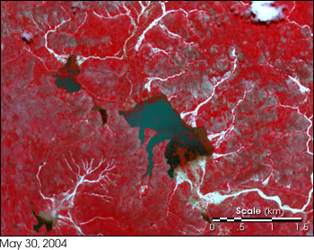
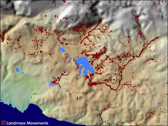
The town of Fond Verrettes lies upstream of the town of Jimani along the same river system. Fond Verrettes also was severely damaged by flooding and landmass movements. On the other side of the massif, ponding of water created a series of lakes, one of which submerged the town of Mapou. Note the extensive landslide and mudflow scars, where receding floodwaters left deposits of gravel, indicated in white. At least seven lakes have appeared where no lakes existed before. Classification of the lake deposits and gravel/mudflow/landslide scars reveals the extent to which the flooding modified the land surface. Mapou lies submerged in the southeastern part of the largest lake. |
Analysis of NASA SRTM data acquired prior to the May 2004 flood event reveals that Jimani was built on a pre-existing floodplain. Note the light-colored depression astride the river channel, indicating the extent of the floodplain. The Dartmouth Flood Observatory and NASA are collaborating to use SRTM and other satellite data to map other such areas where humans are building settlements that are potentially in harms way. (Image courtesy Robert Brakenridge, Dartmouth Flood Observatory) |
 |
 |
This disaster illustrates the continuum between severe storms (including hurricanes), flooding, and landslides (or other landmass movements). For example, we observed the links between these same phenomena in the wake of Hurricane Mitch in October and November 1998, which dramatically affected the Central American countries of Guatemala, Honduras, and Nicaragua. In that event, intensely heavy rains generated more than 10,000 landslides, making it the largest single landslide-generating event yet recognized. This May 2004 Haiti/Dominican Republic event is similar in scope to the Hurricane Mitch event in terms of how widely the debris-laden floodwaters modified the landscape. |
These detailed images from NASA’s Terra satellite show the area around Mapou, Haiti, before and after the May 2004 flood event. Whereas the region had no lakes beforehand, the May 30 ASTER image reveals a number of lakes (dark patches) dotting the landscape. The town of Mapou lies submerged in the largest of the lakes shown here. The bright branching patterns are flow channels filled with gravel that was swept down the southern flank of the Massif de la Salle. (Click for more details. NASA image by Jesse Allen, using data courtesy ASTER Science Team) |
 |
|
A key question concerning this event is: How often do floods and related landmass movements that cause casualties occur in Haiti? Analysis of the Dartmouth Flood Observatory data archive, which dates back to 1986, suggests that major floods in the Dominican Republic/Haiti are now a near-annual event. Since 1986, twelve lethal events have impacted the island, including:
Four of these events occurred in spring or early summer, and seven in the late summer or late fall tropical storm season. Thus spring flood events are relatively common; flood events are not restricted to the rainy season. This particular spring has been abnormally rainy throughout the Caribbean and adjacent parts of Central America. Hurricane season officially began on June 1, bringing the potential for more severe weather this year that could further aggravate the situation. This article is a result of collaboration between the SIAM-SERVIR Project and the Dartmouth Flood Observatory, which is funded in part by the Applications Division within NASA’s Earth Science Enterprise. |
Massive runoff along the southern flank of the Massif de la Salle, generated by torrential rains, formed new lakes in southeastern Haiti and modified the landscape by sweeping tons of debris and gravel downstream. The new lakes are shown here in light blue while the red highlights show the extent of the areas affected by landmass movements. (Map courtesy Robert Brakenridge, Dartmouth Flood Observatory) |