 |
|||
In early 1991, Mt. Pinatubo, a volcano north of Manila on the Philippine island of Luzon, had been dormant for more than 500 years. Few geologists would have guessed that it would produce one of the world’s most explosive eruptions in the twentieth century. Indications of unrest started a few months before the June 1991 eruption, but the size and impact of the eruption were completely unexpected. During the June 12-15 eruptive climax, the top of the mountain was blown off, lowering the elevation by roughly 150 m. About 8 to 10 km2 of material (Scott, et al., 1996) spewed out of the volcano onto the surrounding slopes. The eruption forced evacuation of more than 50,000 people, and effectively shut down two major US military bases (Clark Air Force Base and Subic Bay Naval Base); it was ultimately responsible for taking several hundred human lives. |
|||
|
|||
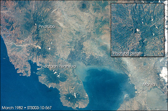
Before the eruption, Mt. Pinatubo was a forested, deeply dissected and unimposing mountain on Luzon’s Bataan Peninsula. Although the upper slopes were steep and not well suited for agriculture, the lower slopes were heavily populated and supported extensive rice fields. |
This photograph was taken by Space Shuttle astronauts in March 1982, 9 years before the eruption. At the time of this photograph, the elevation of Mt. Pinatubo was 1745 m. Manila, a city of 10 million people, lies 100 km southeast of Pinatubo. NASA image STS003-10-567. | ||
|
|||
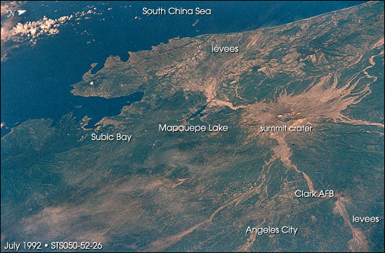
During the eruption, the upper slopes of the mountain suffered immediate destruction. The climactic explosions of June 14–16, 1991, blasted away the summit of Pinatubo, blew down surrounding forests, and rained hundreds of cubic meters of loose sand and gravel down on the mountain’s upper slopes. Floods of hot volcanic slurries were responsible for long-lasting damage downslope. Astronauts did not observe the June 1991 eruption of the volcano—but they have routinely monitored subsequent changes around Mt. Pinatubo. The eruption had two major environmental effects which are readily documented from low-Earth orbit: the distribution of vast quantities of sulfur dioxide aerosols into the stratosphere; and the post-eruption mudflows, or lahars, which are recognized as the major natural hazard from the eruption.
The data used in this study are available in one or more of NASA's Earth Science Data Centers. |
This view was taken by Shuttle astronauts looking westward over Mt. Pinatubo about one year after the volcano erupted; it shows much of the regional damage. The summit of Pinatubo was blasted away, the forests were blown down, and hundreds of meters of loose sand and gravel rained down on the mountain’s upper slopes. The light-colored mud-filled rivers radiating away from the summit were the scene of floods of hot volcanic slurries streaming down the mountain slopes. NASA image STS050-52-26. | ||