The Earth Observatory has published its last Image of the Day on this website. Please join us on our new home at science.nasa.gov/earth/earth-observatory.
 | |||
|
|||
If there’s one thing atmospheric scientists have discovered about clouds in recent years it’s that they still have much to learn about them. Sure, scientists know what clouds look like, what they’re made of, and how and why they form and dissipate. But they are struggling to predict how clouds will change in the future. Specifically, how will their composition, structure, and extent change if the surface of our planet grows significantly warmer? Two teams of scientists surprised the Earth science community recently by publishing evidence that tropical atmospheric circulation patterns are more intense in the 1990s than the 1980s, thereby changing the structure and extent of clouds in the tropics (Wielicki, et al. 2002; Chen et al. 2002). |
Arbiters of Energy Part 1: The Iris Hypothesis
| ||
| |||
One indicator for how well scientists understand a given phenomenon of nature is how well they can predict it. It is inherently difficult to predict cloud behavior because there are so many variables that are constantly changing over time and space, and these variables influence one another (such as surface temperature and air temperature, wind currents, varying amounts of water vapor, abundance of aerosol particles, etc.). All meteorological models inevitably fail at some point due to the sheer complexity of the Earth’s system. In fact, chaos theory shows that weather will never be predictable with any significant accuracy for longer than 2 weeks, even with a nearly perfect model and nearly perfect input data. So missing a prediction of cloudiness on a given day is no big surprise. But climate is the average of many weather events, and may be predictable at longer time scales ranging from seasons to decades to centuries. Today, climate models are in an early development stage somewhat similar to the status of weather prediction 30 years ago. As a result, the recent observations of cloudiness changes from the 1980s to the 1990s are particularly useful tests of how well the models perform. So far, the climate observations and climate models don’t agree very well. But why even bother with clouds? Why do we care about them? Clouds are the arbiters the Earth’s energy budget. They are so
plentiful and widespread, clouds cover up to 60 percent of our planet at any
given time. They play a major role in governing how much sunlight reaches the
surface, how much sunlight is reflected back up to space, how and where warmth
is spread around the globe, and how much heat escapes from the surface and
atmosphere back into space. In short, clouds are a key component of
Earth’s climate system, and scientists cannot construct accurate global
climate models until they gain a better understanding of cloud physics. |
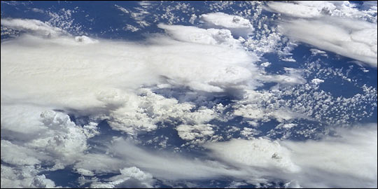
Clouds play a crucial role in regulating the balance of energy received by and emitted from the Earth, but scientists aren’t sure exactly what this role is. How much solar energy do different types of clouds reflect? How much heat do clouds trap? How will clouds change as humans change the Earth’s surface and atmosphere? New satellite instruments and controversial theories are motivating scientists to answer these questions. (Photograph STS096-724-20 courtesy the Earth Sciences and Image Analysis Laboratory at Johnson Space Center.) | ||
Currently, scientists are focusing their attention on
the tropics because,
over the course of a year, the tropics receive more of the sun’s warmth
than anywhere else on Earth. Air and ocean currents help spread this warmth
toward the poles. Since the tropics are covered mostly by warm ocean water and
since warmer water evaporates more readily, there is a direct relationship
between higher sea surface temperatures and cloud formation. Certain types of
clouds (i.e., marine stratocumulus) tend to cool the surface by reflecting
sunlight, and certain types of clouds (i.e., cirrus) tend to warm the surface by
allowing sunlight to pass through and then trapping the heat radiated by the
surface. So there is a physical feedback loop between sea surface temperature
and cloud formation in that each influences the other. |
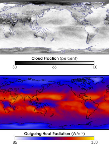
Clouds trap energy in the atmosphere. These two images compare cloud fraction (ranging from 0 to 100 percent cloudy) to escaping heat radiation during the month of February 2002. The areas of most continuous cloud coverage correspond to the lowest amounts of heat radiating out into space. This is apparent in Indonesia, Africa, and South America. (Images by Reto Stöckli, based on data from the MODIS and CERES science teams.) | ||
This understanding frames the importance of the original question: How will tropical clouds change if tropical sea surface temperatures warm significantly? One team of scientists recently proposed that the Earth has a built-in mechanism for changing the structure and distribution of certain types of clouds in the tropics to release more radiant energy into outer space as the surface warms (Lindzen et al. 2001). Dubbed the “Iris Hypothesis,” this theory generated considerable buzz among science and political circles alike because, if true, it would mean that the Earth’s climate system naturally counteracts global warming by allowing more heat to escape through the top of the atmosphere. But when another team of scientists at NASA’s Langley Research Center (LaRC) plugged these satellite measurements into the same Iris Hypothesis model, they found a slight increase in surface temperatures (Lin et al. 2001). How can the same model produce two very different results? The answer, it turns out, is that all clouds are not created equal. The answer you get depends heavily on the type of cloud you assume in your model. Part one of this three-part series of articles on tropical clouds presents an overview of the Iris Hypothesis as well as the contrasting findings of the NASA LaRC Team. A second science team examined the Iris Hypothesis in light of current understanding of general circulation patterns within the ocean and atmosphere. Led by Dennis Hartmann, a physicist within Washington University’s Department of Atmospheric Sciences, this second team had major disagreements with some of the key assumptions made by Lindzen’s team (Fu et al. 2001). Thus, when they repeated Lindzen’s model experiment, they arrived at significantly different findings. Moreover, based upon their own analysis of the data, they report that none of the shrinkage in cirrus clouds proposed by Lindzen is due to an increase in sea surface temperature (Hartmann and Michelsen 2002). Part two of this three part series of articles presents an overview of current research into oceanic and atmospheric circulation patterns around the globe and how factors outside of the tropics can influence cloud formations within the tropics (Lau et al. 1997). Yet recent satellite remote sensing data suggest that the structure and amount of tropical clouds (located between 30°N and 30°S latitudes) has changed substantially from the 1980s to the 1990s, thereby influencing the Earth’s radiant energy budget (Wielicki et al. 2002). The evidence for the change in cloud patterns, according to another team of scientists led by Junye Chen at NASA’s Goddard Institute for Space Studies, points to an overall strengthening of tropical atmospheric circulation patterns through the 1990s (Chen et al. 2002). Could this be a signal that the climate system is changing? Or, is the change merely a short-term anomaly? The third article in this three-part series will explore in detail these new findings and discuss their implications within the context of global warming.
The data used in this study are available in one or more of NASA's Earth Science Data Centers. |
 Like the iris in the human eye expands to allow more light to enter the pupil, one team of scientists recently suggested that tropical clouds may contract to allow more heat to escape to space. This idea was dubbed the “Iris Hypothesis.” (Photograph courtesy Philip Greenspun) | ||