The Earth Observatory has published its last Image of the Day on this website. Please join us on our new home at science.nasa.gov/earth/earth-observatory.
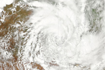
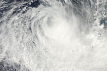
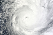
Still soaking from months of rain and major floods, the residents of eastern Australia braced for the arrival of Cyclone Yasi in early February 2011. The storm was hovering in strength between category 4 and 5, the most damaging on the hurricane classification scale.
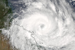
This natural-color image shows Yasi approaching the coast at 1:35 p.m. Australian Eastern Standard Time (03:35 Universal Time) on February 2. The image was acquired by the Moderate Resolution Imaging Spectroradiometer (MODIS) on NASA's Aqua satellite.
At 10 p.m. local time (12:00 UTC) on February 2, shortly before Yasi reached the coast, the storm packed sustained winds of 250 kilometers (155 miles) per hour, with gusts to 305 kilometers (189 miles) per hour, according to the Joint Typhoon Warning Center.
News reports stated that the storm made landfall between Innisfall and Cardwell, south of Cairns, Queensland, around midnight on February 3. Storm surges along the coast were predicted to be as high as 9 meters (30 feet).
NASA image courtesy Jeff Schmaltz, MODIS Rapid Response Team at NASA GSFC. Caption by Mike Carlowicz.