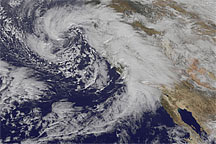
A series of strong storms pounded California in January 2010. Fierce winds and heavy rains downed power lines and flooded streets as the National Weather Service warned residents to brace for as much as 20 inches (50 centimeters) of rain in five days. A likely tornado flipped a car, smashed windows, and ripped a roof in Orange County on January 19. On January 20, authorities ordered the evacuation of 800 homes in the Los Angeles foothills, fearing mudslides from areas devastated by the previous summer’s Station Fire.
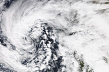
The Moderate Resolution Imaging Spectroradiometer (MODIS) on NASA’s Aqua satellite captured this true-color image on January 20, 2010. Over the Pacific Ocean and the California coast, clouds assume the shape of a giant apostrophe, looking vaguely like a hurricane missing most of its center. The storm’s shape suggests a low-pressure system drawing in strong winds from nearby areas. Patches of clear sky allow glimpses of California’s Central Valley and Baja California.
The storms striking Southern California were the strongest since at least 2005, according to news reports. Although less violent in Northern California, storm activity there led to power outages. As of January 21, forecasters warned that another storm was approaching the state.
NASA image courtesy MODIS Rapid Response Team at NASA GSFC. Caption by Michon Scott based on image interpretation by Walt Meier, National Snow and Ice Data Center.