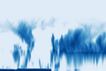
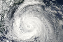
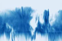
Hurricane Bill moved quickly northward through the Western Atlantic in the third week of August 2009, staying well away from the U.S. East Coast, but pounding the seaboard with large surf. This pair of images from August 22 shows a natural-color (photo-like) view of Hurricane Bill captured by the Moderate Resolution Imaging Spectroradiometer (MODIS) on NASA’s Aqua satellite (top) combined with a view of the vertical structure of the clouds measured by the radar on the Cloudsat satellite (bottom).
The photo-like view has been rotated so that North is to the right. The gray line shows the track that Cloudsat followed as it passed from south to north over the storm shortly following Aqua. The radar reflectivity measured by Cloudsat is the echo made when the pulse of energy the radar sends out bounces back from the ocean surface or from cloud particles in the atmosphere. The radar picture gives an idea of the shape and height of the clouds you would have seen if you could have sliced away the eastern half of the storm and looked in at it from the side.
As Cloudsat flew over the storm, it first encountered only patchy clouds, followed by the outermost band of clouds associated with the hurricane. As the radar scanned northward, it saw a pocket of air that was mostly cloud free; only a thin patch of high-altitude cirrus clouds capped a column of relatively clear air. Clouds in the southern eye wall reached about 15 kilometers in altitude, while those to the north were lower.
NASA image created by Jesse Allen, using CloudSat FirstLook data provided courtesy of the CloudSat team at Colorado State University. Caption by Rebecca Lindsey.