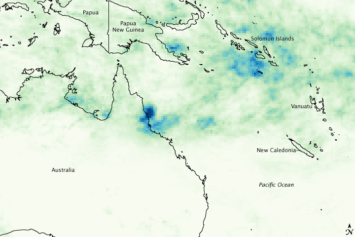


After forming about 175 kilometers (about 110 miles) from the northeast coast of Queensland, Australia, over the weekend of February 1, Cyclone Ellie made landfall at just after midnight (Australian EST) Monday, February 2nd, 2009, at Mission Beach between Townsville and Cairns. Despite making landfall as just a Category 1 cyclone (equivalent to a tropical storm on the U.S. Saffir-Simpson scale), the storm caused widespread flooding across the region. Total rainfall from tropical cyclones depends more on their residence time over an area than their intensity, and Ellie was a slow-moving system.
This image shows rainfall totals for January 27 through February 3, 2009, for northeastern Australia and the surrounding region. The highest rainfall totals (shown in dark blue) exceed 400 millimeters (about 16 inches); they are located right along the coast where Ellie made landfall. Most of northern Queensland received in excess of 100 millimeters (about 4 inches) of rain. More rain was expected for the region as a broad monsoon trough remained in place across northern Australia.
These rainfall estimates were calculated by the near-real-time, Multi-satellite Precipitation Analysis produced at NASA Goddard Space Flight Center. The system is based largely on data from the Tropical Rainfall Measuring Mission satellite (TRMM). TRMM, which carries the first precipitation radar in space, is a joint mission between NASA and the Japanese Space Agency, JAXA.
NASA image created by Jesse Allen and Hal Pierce. Caption by Steve Lang (SSAI/NASA GSFC).