
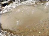
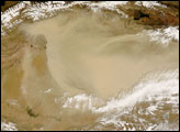
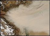
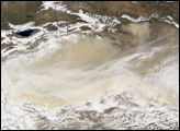
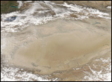
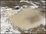
Dust storms covered much of the Taklimakan Desert in western China in early May 2008. By the time the Moderate Resolution Imaging Spectroradiometer (MODIS) on NASA’s Terra satellite took this picture, on May 2, 2008, the storm had intensified since the previous day.
In this image, the dust plumes appear as beige blurs hiding the tan-colored landscape below. Aside from an isolated plume in the west, the dust plumes merge into one large cloud blowing toward the east. Snowcapped mountain ridges fringe the desert in the northwest and southwest. Clouds also hover along the desert’s southern margin, perhaps associated with the same weather system that stirred the dust.
The Taklimakan Desert occupies the Tarim Basin between the Tien Shan Mountains in the north, and Kunlun Mountains in the south. The lowest point of this basin is about 150 meters (almost 500 feet) below sea level, and because the area has no drainage, large quantities of salt and sand have collected in the basin. The mountains to the north block cold air from the Arctic, and the location’s distance from the ocean eliminates monsoon-related precipitation, so the area remains warm and dry. It is one of the largest shifting-sand deserts on Earth.
NASA image courtesy of Jeff Schmaltz, MODIS Rapid Response Team, NASA-Goddard Space Flight Center. Caption by Michon Scott.


