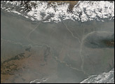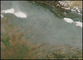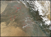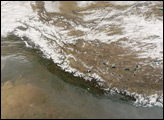
Haze was pooled along the foothills of the Himalaya Mountains over the Ganges and Brahmaputra Rivers on January 17, 2006, when the Moderate Resolution Imaging Spectroradiometer (MODIS) on NASA’s Terra satellite passed overhead and captured this image. To the north, skies over the Tibetan Plateau were crystal clear, revealing the winter-bare landscape, as well as clear and ice-covered lakes.
Rapid urbanization, industrialization, and explosive population growth have caused India’s air quality to deteriorate. Vehicle ownership has increased with the population growth and rising income levels, and particulate matter (PM) pollution from vehicles is the largest source of pollution in large urban areas such as New Delhi. Emissions from coal-burning power plants are another major source of particle pollution.
A 250-meter-resolution KMZ file of the Himalaya Range is available for use with Google Earth.
NASA image created by Jesse Allen, using data provided courtesy of the MODIS Rapid Response team.