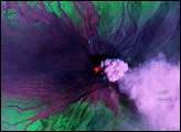

The Tungurahua Volcano in Ecuador had been acting up for more than a month when it erupted ferociously in mid-August 2006. According to the Associated Press, the volcano destroyed 10 villages, and buried the homes of roughly 5,000 people—as well as the pasture for their livestock—under tons of ash. Several days after the eruption, authorities began rebuilding homes for displaced locals who needed food for themselves and their animals, along with shelter from the elements.
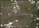
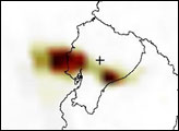
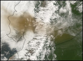
Besides inundating the locals, Tungurahua Volcano spewed volcanic ash into the atmosphere. The Ozone Monitoring Instrument (OMI) flying onboard the Aura satellite measured the aerosols in the region on August 17, 2006, the day after the volcano’s fierce eruption. This image shows an ash cloud superimposed on a map of the region. A plus sign marks the volcano summit, and the volcanic ash appears in two distinct plumes: a larger one west of the summit, and a smaller one to the east. This aerosol distribution vaguely matches the volcanic material shown in the MODIS image from the same day. In this image, dark reddish-brown indicates the thickest ash, while tan indicates relatively thin ash.
Images courtesy Colin Seftor, Aura Science Team.
Tungurahua Volcano in Ecuador began emitting a volcanic plume of ash and/or steam in late June 2006. The volcano erupted seriously in August, destroying three villages. This new image shows an eruption in December.


