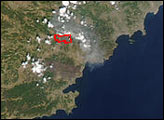
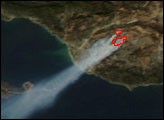
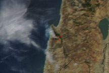
Between Monday afternoon and Tuesday morning, a fast-moving forest fire near St. Maxime, France, on the Mediterranean coast, consumed nearly 16,000 acres of woodland. All that remained on the morning of July 29, 2003, was a plume of yellow-gray smoke that had spread eastward over Italy (top image) and a dramatic burn scar (bottom right image).
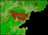
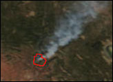
These images from the Moderate Resolution Imaging Spectroradiometer (MODIS) on the Terra and Aqua satellites tell the story of the blaze. The area of the close-up images on the bottom is marked with a white square in the top view. In the two false-color image at bottom, the scar (brick red area) from a fire that burned the pervious week (left image) appears to nearly double in size overnight (right image). The recent fire must have flared up and then died out very quickly since a thermal signature was not detected by MODIS during either the Aqua satellite overpass on Monday afternoon or the Terra satellite overpass on Tuesday morning.
The high-resolution image provided above is of the top scene at 500 meters per pixel. The MODIS Rapid Response System provides all images at MODIS? maximum spatial resolution of 250 meters: July 28, and July 29.
Images courtesy Jacques Descloitres and Jeff Schmaltz, MODIS Rapid Response Team, NASA GSFC
alert message