For many people who traveled long distances and faced epic traffic jams to reach the path of totality of the April 8, 2024, total solar eclipse, clouds loomed as the potential spoiler. The wrong type of cloud in the wrong location at the wrong time could easily ruin the ethereal view of the Sun’s corona shimmering around the silhouette of the Moon that eclipse watchers sought.
But for thousands of people who collected data for GLOBE Eclipse, a NASA citizen science project, clouds were a phenomenon to catalog and study in their own right. “Total solar eclipses are rare enough that the observational record of clouds and eclipses is still sparse,” said Marilé Colón Robles, the project scientist for GLOBE Clouds. “There are still plenty of unanswered questions about clouds and total solar eclipses.”
Among them: How does the magnitude of the brief temperature decline vary depending on cloud conditions? And to what extent, if any, might the eclipse contribute to changes in convective clouds that are observable from the ground or with satellites? “The relatively large and abrupt perturbation of the atmosphere during an eclipse can be used to test and improve our theoretical understanding and numerical simulations of atmospheric processes, things key to weather forecasting and other types of atmospheric modeling,” added Colón Robles. “The eclipse offered a perfect ‘natural experiment’ to do that.”
One easy way citizen scientists collected data to help the scientific community answer these questions was via smartphones. For about a month prior to the eclipse, the GLOBE team encouraged their network of observers to download their app and collect observations of clouds leading up to and on eclipse day. When the day finally arrived, more than 7,000 citizen scientists—including students and teachers—collected photos of cloud conditions before, during, and after the eclipse. Many people also used thermometers to measure air temperatures, following protocols developed by the GLOBE team.
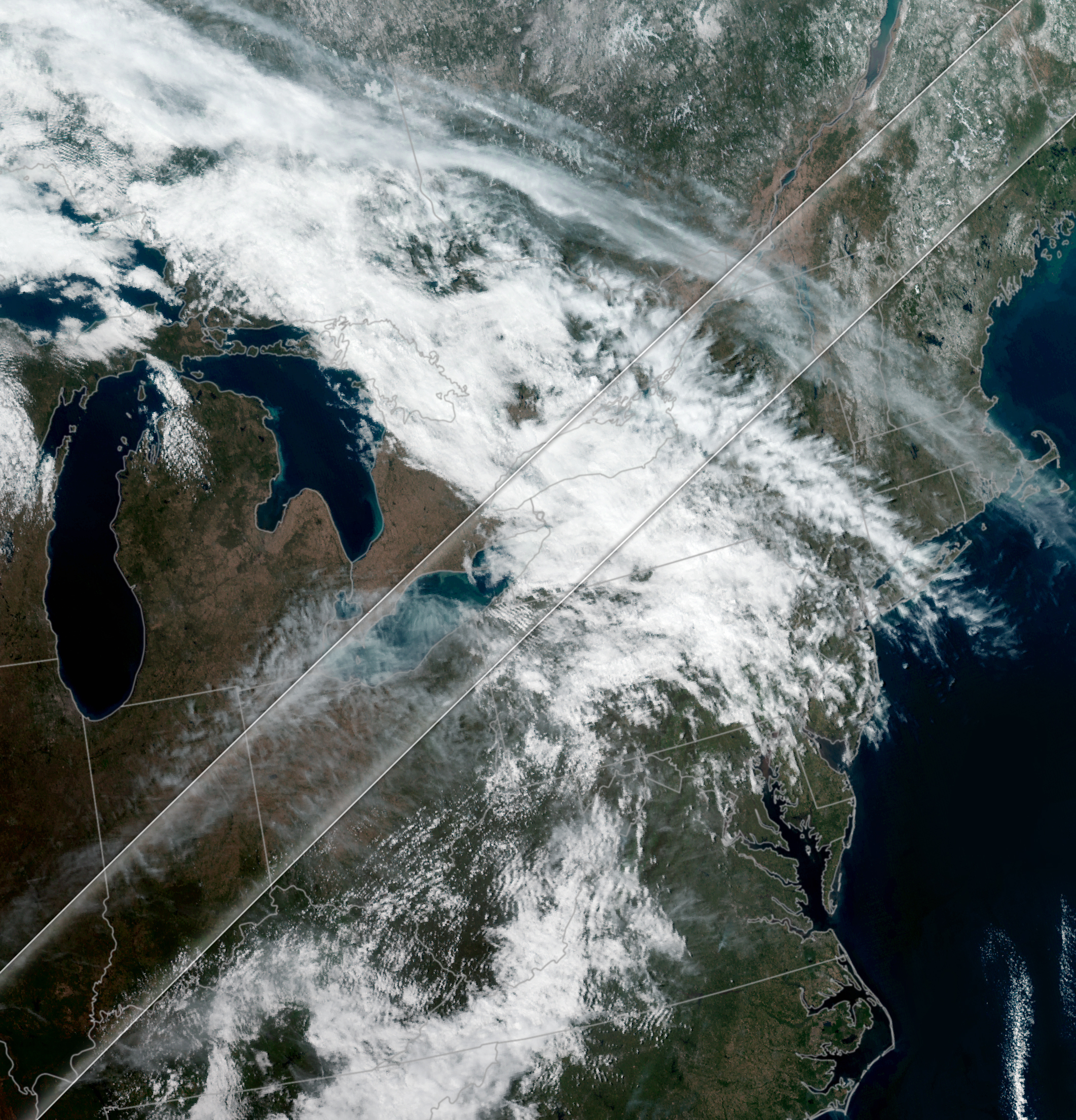
The image at the top of the page highlights the variety in the clouds that the ABI (Advanced Baseline Imager) on the GOES-16 (Geostationary Operational Environmental Satellite-16) satellite observed at 18:40 Universal Time, about 1 hour before the Moon’s shadow passed over the region.
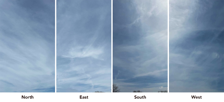
The set of photos above were collected by Colón Robles near Mentor, Ohio, at 18:39 UTC. Many images like these submitted through the GLOBE Observer app were automatically paired with satellite images acquired at roughly the same time. With photos taken in multiple directions and looking straight overhead, it is easier to match cloud features in photos taken on the ground with clouds features in corresponding satellite images.
An eclipse forecast from NASA’s GMAO (Global Modeling and Assimilation Office) based on the GEOS-FP (Goddard Earth Observing System Forward Processing) model released a day before the eclipse suggested that there would be plenty of clouds to catalog. The forecast called for overcast skies in many parts of Pennsylvania and New York as a low-pressure system situated in the upper-Midwest roiled the area. Meanwhile, a southerly branch of the jet stream pulled moist, humid air in from the south that created a line of tall convective storm clouds across Texas, explained Bennett Erdman, a meteorologist with GMAO.
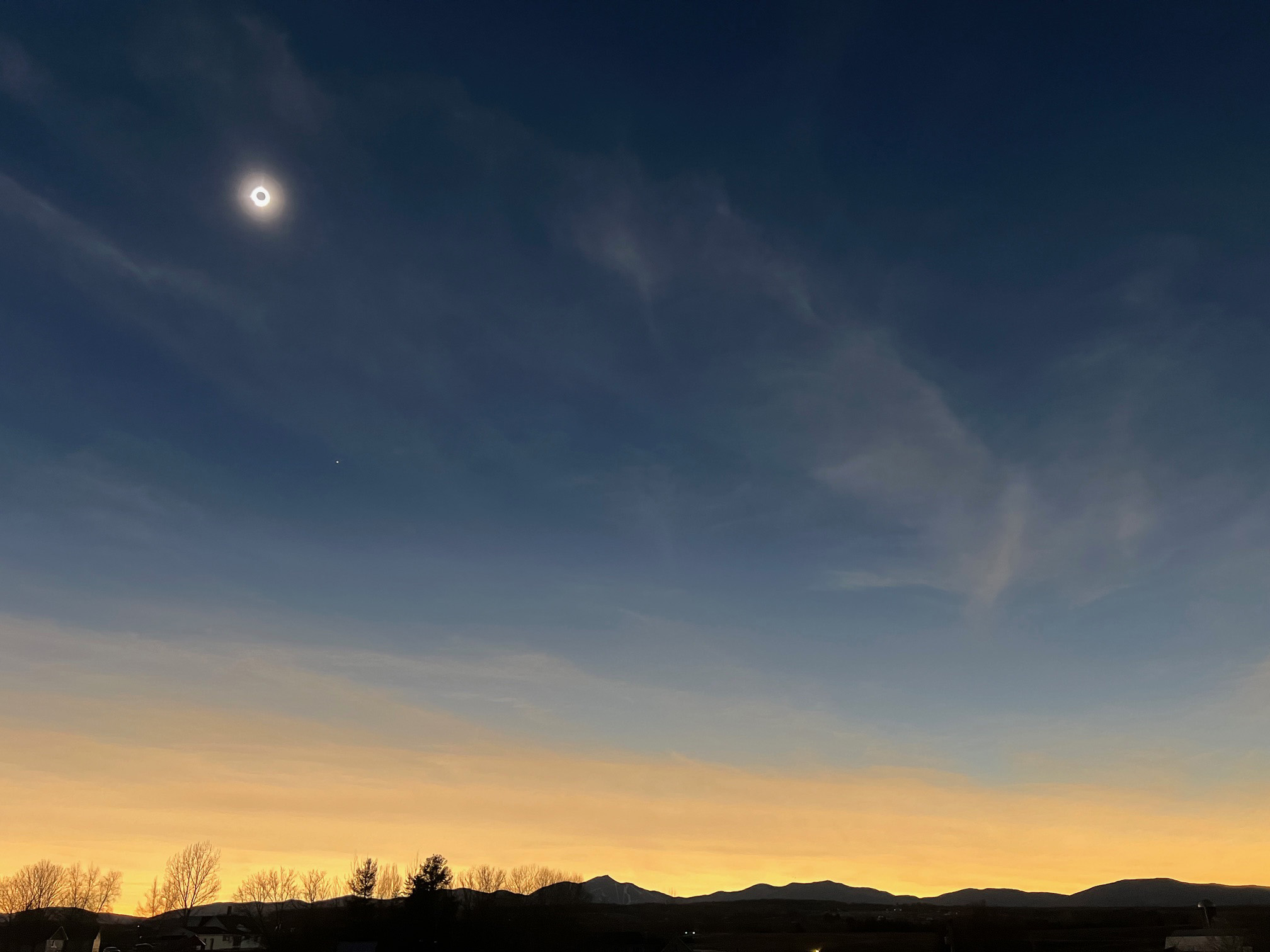
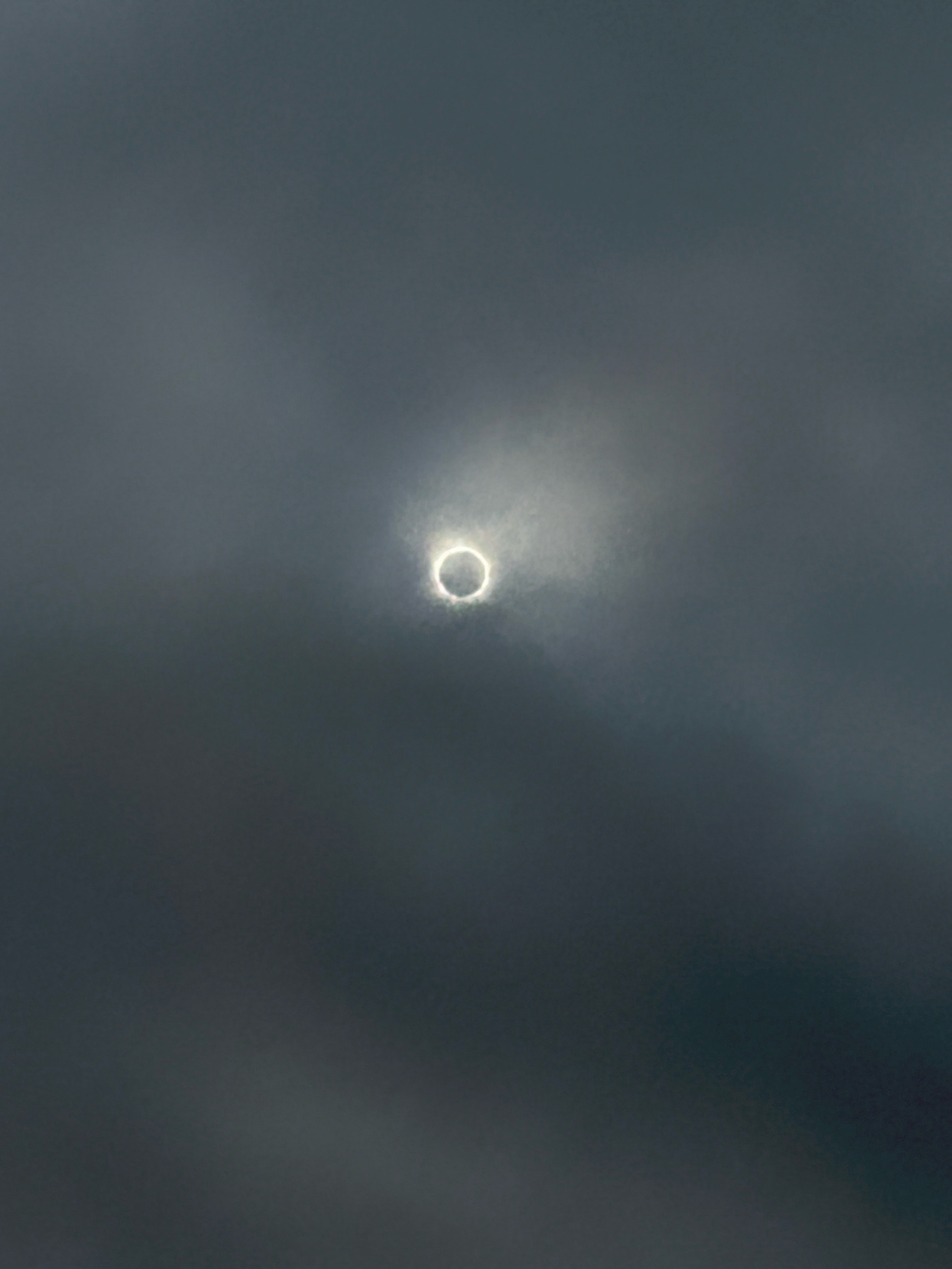
While skies in Vermont and New Hampshire were relatively clear before the eclipse, a thin layer of cirrus clouds at the leading edge of the frontal system in the Midwest pushed in from the southwest as totality neared. “That it was just cirrus clouds was good news for people in northern New England because cirrus clouds are made up of ice particles rather than water droplets and are thus quite transparent to shortwave radiation, allowing a high amount of visible light to pass through,” explained Erdman.
As shown in this photograph (above), taken in Newport, Vermont, northern New England had spectacular viewing conditions, even in areas with some cirrus clouds. Viewing in most of Ohio, Indiana, Illinois, Missouri, and Arkansas also fared generally well. Skies were mostly either clearing, or contained cirrus or scattered cumulus clouds that didn’t completely block the view of totality. In contrast, many parts of Texas, such as Kerrville (below), faced decks of mid-level or low-level clouds.
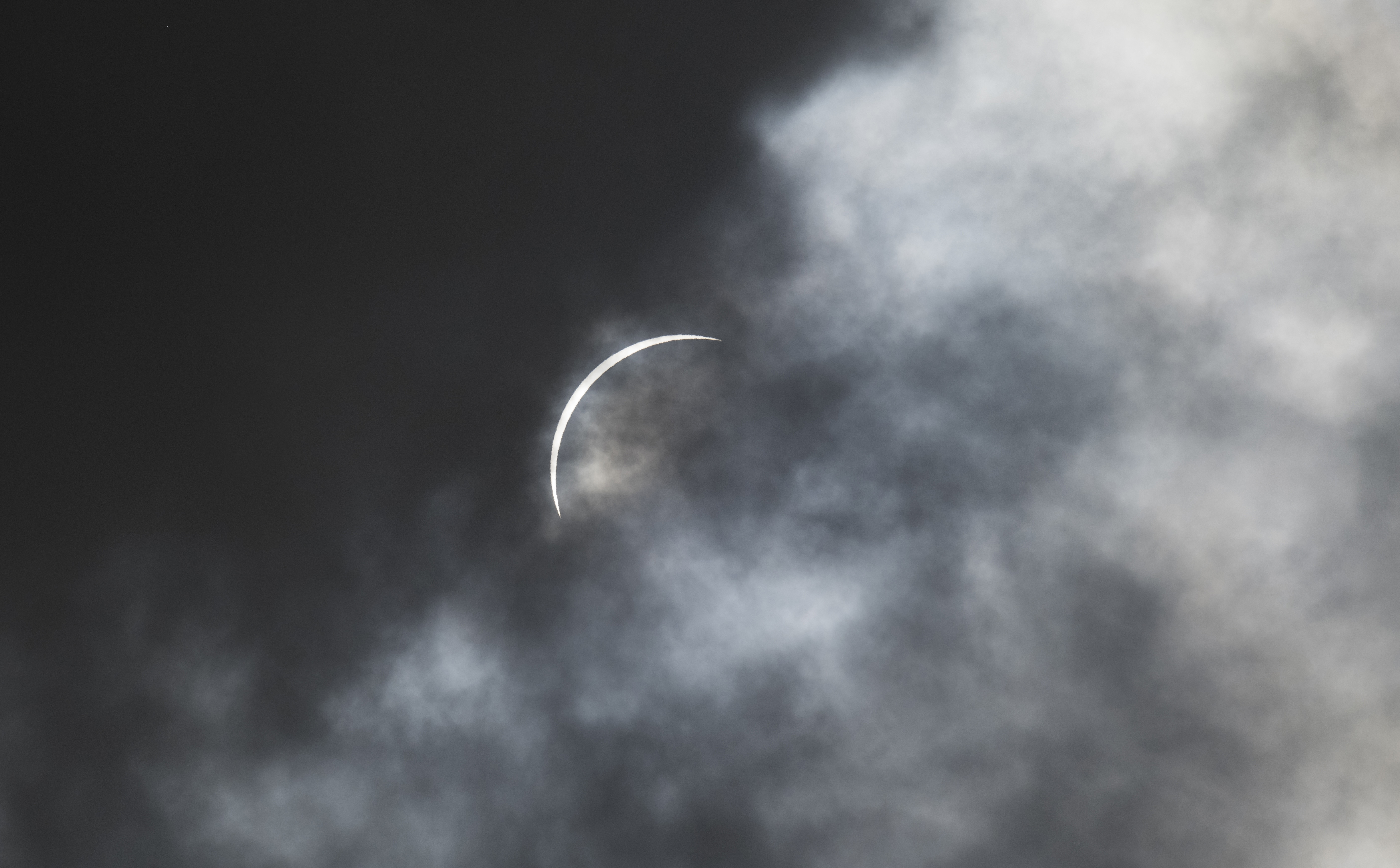
Eclipse watchers in some parts of New York were not fortunate, either. With layers of low stratocumulus clouds rolling through the state during much of the eclipse, a blanket of gray blocked the view in many areas. Occasional breaks in the thickest cloud cover, such as the view from Syracuse (below), provided some interest, but the view of the corona was often fuzzy and opaque, if visible at all.
The GLOBE team is just starting to assess and analyze the thousands of observations from April 8, 2024, and their full analysis is still several months away. However, their analysis of data collected during the total solar eclipse in 2017 revealed a relatively small drop in air temperatures in cloudy areas compared to clear areas. The average temperature drop from all temperature observations during the 2017 eclipse was about 7 degrees Fahrenheit (4 degrees Celsius), and areas with more cloud cover saw less of a temperature drop.
Other teams of researchers have reported that solar eclipses can change temperatures enough to cause certain types of convective clouds to begin to dissipate in the early stages of total solar eclipses. “We don’t have definitive evidence for that so far in our data,” Colón Robles said, “but it’s something we’ll certainly look for as we analyze the data.”
The GLOBE Eclipse project is motivated by another goal that’s far harder to measure than decreases in temperature during the eclipse. “Totality is an unforgettable experience,” said GLOBE Observer project coordinator Holli Kohl. “We’ve heard from people that seeing a total solar eclipse is the kind of experience that inspired them to become meteorologists or climatologists or astronauts, and we certainly hope that offering people the opportunity to work hand-in-hand with NASA to collect data will nudge them in that direction.”
NASA Earth Observatory image by Michala Garrison, using GOES 16 imagery courtesy of NOAA and the National Environmental Satellite, Data, and Information Service (NESDIS). Mentor, Ohio, set of photographs courtesy of NASA GLOBE Program/Marilé Colón Robles. Northern Vermont photo courtesy of NASA/Valerie Casasanto. Kerrville photo courtesy of NASA/Aubrey Gemignani. Syracuse photo courtesy of NASA/Rosalba Giarratano. Story by Adam Voiland.