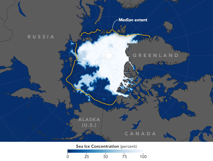


Arctic sea ice appeared to reach its annual minimum extent on September 10, 2016, NASA and the National Snow and Ice Data Center (NSIDC) reported today. An analysis of satellite data showed that sea ice around the North Pole shrank to 4.14 million square kilometers (1.60 million square miles).
The 2016 sea ice minimum is effectively tied with 2007 for the second lowest in the satellite record. Since satellites began monitoring sea ice in 1979, researchers have observed a decline in the average extent of Arctic sea ice in every month of the year.
The map above shows the extent of Arctic sea ice on September 10, 2016. Extent is defined as the total area in which the ice concentration is at least 15 percent. The map was compiled from observations by the Advanced Microwave Scanning Radiometer 2 (AMSR-2) sensor on the Global Change Observation Mission 1st–Water satellite operated by the Japan Aerospace Exploration Agency (JAXA). The yellow outline shows the median sea ice extent observed in September from 1981 through 2010.
The sea ice cover on the Arctic Ocean and surrounding seas regulates the planet’s temperature, influences the circulation of the atmosphere and ocean, and affects life in Arctic communities and ecosystems. The ice cap shrinks every year during the spring and summer until it reaches its minimum extent in September. Sea ice grows during the late autumn and winter months, when the Sun is below the horizon in the Arctic Circle.
The 2016 melt season surprised scientists by changing pace several times. It began with a record-low yearly maximum in March, followed by rapid ice losses through May. But in June and July, low atmospheric pressures and cloudy skies slowed melting. Then, after two large storms blew across the Arctic basin in August, sea ice melting accelerated through early September.
“It’s pretty remarkable that this year’s sea ice minimum extent ended up the second lowest after how the melt progressed in June and July,” said Walt Meier, a sea ice scientist with NASA’s Goddard Space Flight Center. “June and July are usually key months for melt because that’s when you have 24 hours of sunlight each day. This year we lost momentum during those two months.”
In August, two strong cyclones crossed the Arctic Ocean along the Siberian coast. The storms did not have an immediate impact, as a great cyclone did in 2012. But in late August and early September, Meier noted, there was “a pretty fast ice loss in the Chukchi and Beaufort seas that might have been a delayed effect from the storms.”
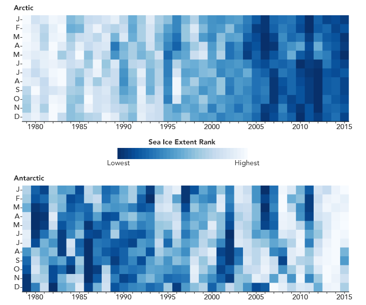
New research affirms that Arctic sea ice has not fared particularly well in any month in the past three decades. An analysis by Claire Parkinson and Nicolo DiGirolamo of NASA Goddard ranked 37 years of monthly sea ice extents in the Arctic and Antarctic. They found that there has not been a record high in Arctic sea ice extent in any month since 1986. During that same period, there have been 75 new record lows. That pattern is reflected in the graph below.

“It is definitely not just September that is losing sea ice. The record makes it clear that the ice is not rebounding to where it used to be, even in the midst of the winter,” Parkinson said. “When you think of the temperature records, it is common to hear the statement that even when temperatures are increasing, you expect a record cold month every once in a while. To think that in this record of Arctic sea ice there hasn’t been a single record high in any month since 1986, it’s just an incredible contrast.”
Parkinson also found that in the Antarctic, where the trends are toward more sea ice, there have only been six record monthly lows since 1986 and 45 record highs. This is reflected in the second half of the graph above.
“The Antarctic numbers are pretty amazing,” Parkinson said, “except when you compare them with the Arctic’s, which are much more amazing.”
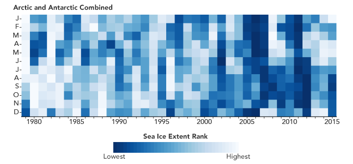
The graph below combines total Arctic and Antarctic monthly extents for each month since 1979. When you combine the strong downward trend in the Arctic with the weaker upward trend in the Antarctic, the global results show an overall downward trend in sea ice extents.

NASA Earth Observatory images by Joshua Stevens, using data from the Advanced Microwave Scanning Radiometer 2 (AMSR-2) sensor on the Global Change Observation Mission 1st-Water (GCOM-W1) satellite, the Scanning Multichannel Microwave Radiometer (SMMR) on the Nimbus-7 satellite, and analyses from Parkinson and DiGirolamo (2016). Caption by Maria-Jose Vinas Garcia, with Mike Carlowicz.