The Earth Observatory has published its last Image of the Day on this website. Please join us on our new home at science.nasa.gov/earth/earth-observatory.
This week marks the 100th anniversary of the National Park Service. We are celebrating this milestone with a gallery of images that you can see here.
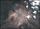
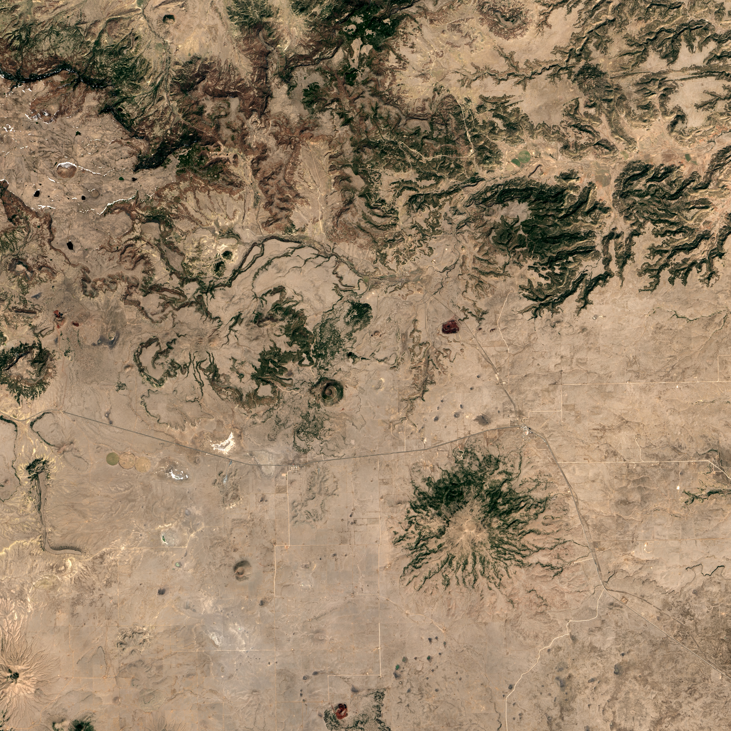
Capulin Volcano National Monument has watched over the surrounding plains for millennia. It has stood like a sentinel over the West’s cattle boom and the trains headed for the Mexican-American war.
Nestled in the northeast corner of New Mexico, Capulin protrudes from the flat expanse, an anthill of giant proportions. A bowl-shaped crater tops the steep, conical hill. From its perch at the western edge of the Great Plains, it commands a clear view of New Mexico, Colorado, and Oklahoma.
Capulin last erupted roughly 56,000 to 62,000 years ago. The volcano sits near the center of the Raton-Clayton field, a cluster of smaller volcanoes spread across 7,500 square miles (roughly 19,400 square kilometers). The oldest of these date back about 9 million years, while the youngest emerged roughly 45,000 years ago.
Scientists suspect Capulin formed in a series of bursts and starts over a few weeks to several years. After an initial, large eruption that laid the volcano’s foundation, a number of small lava flows and cinder eruptions paved over the mound, steepening its slopes. In cinder-cone eruptions, “the supply of magma is small or episodic, facilitating the cooling and clogging of a vent and subterranean pathway,” according to the National Park Service. Over time, wind has nibbled away at the mound, eroding its surface.
While Capulin volcano probably won’t erupt again, magma may push out of the ground at a new spot in the surrounding volcanic field.
Humans have also shaped the contours of this national monument. A test pit from early cinder mining still pocks Capulin’s base. In the mid-1800s, during the Mexican-American war, trains laden with soldiers and supplies passed near the volcano on their way to the Santa Fe. Then as settlers moved West, ranching took off in the area. With the war over and the West largely settled, the U.S. Congress withdrew the volcano and surrounding land from settlement in 1891. Capulin was designated a national monument on August 9, 1916, just over one hundred years ago.
Today, it draws two-legged and four-legged visitors alike. Numerous mule deer graze around the volcano and in its hills. Elk, black bears, coyotes, and mountain lions roam the surrounding area. The human fingerprint on the volcano is clear from the sky: a satellite photo taken on April 4, 2016, by the Landsat 8 satellite shows a road tracing a vortex from the volcano’s base to a parking lot at its peak.
NASA Earth Observatory image by Jesse Allen, using Landsat data from the U.S. Geological Survey. Caption by Pola Lem.