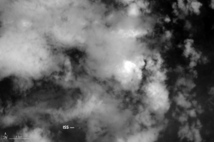
The International Space Station (ISS) flies in an orbit that keeps it about 400 kilometers (250 miles) above the surface of the Earth—roughly the distance between New York and Boston. Meanwhile, Landsat 8, an Earth-observing satellite, cruises at an average altitude of 705 kilometers (438 miles). That means Landsat 8’s Operational Land Imager (OLI) gets a unique view of the Space Station when the orbits of the two spacecraft occasionally align.
On June 19, 2016, they did just that. Landsat 8 acquired images of the ISS amidst a background of clouds over the state of Odisha in eastern India. The animation above is comprised of eight separate images collected just fractions of a second apart. Each image depicts OLI’s observations of electromagnetic radiation at slightly different wavelengths, or spectral bands. The first image in the sequence depicts OLI’s high-resolution observations of blue and green light (Landsat’s pan band); the second depicts blue light; the third is violet; the fourth is near infrared; the fifth is red light; the sixth is green; the seventh is shortwave infrared (2.107–2.294 micrometer wavelength); and the eighth is a different band of shortwave infrared (1.566–1.651 micrometers). The offsets, or motion, in each image is due to the relative speed of the two spacecraft, the altitude of Landsat 8, and the fact that the images were taken at slightly different times.
Space Station underflights of Landsat 8 are relatively rare. “On average ISS underflights seem to happen a few times a year,” explained Michael Gartley, a scientist at Rochester Institute of Technology. Other underpasses in the Landsat 8 archive have occurred on April 17, 2016; February 23, 2016; May 1, 2015; July 4, 2013; June 27, 2013; and May 3, 2013.
The OLI on Landsat 8 is not the only satellite sensor capable of capturing this type of image. The Landsat 7 and 5 satellites have caught glimpses of the ISS in the past. Likewise, the Advanced Land Imager (ALI) on the EO-1 satellite—as well as several high-resolution commercial satellites such as Geoeye, Quickbird, and IKONOS—have pushbroom designs that make it possible to image the underflights of orbiting spacecraft.
In fact, Gartley has developed an algorithm that systematically searches the archive of ALI imagery for underflights, and he is currently working on a similar algorithm for the Landsat 8 archive. As he detailed in a 2013 study, the ALI sensor serendipitously imaged “space objects” on 12 different occasions over the course of a decade. Those objects include a Meteor weather satellite, an Iridium 2 communications satellite, the Space Shuttle (STS-124), orbital debris from several types of rockets, and three Russian Kosmos satellites. In all, there are some 5,000 known objects that orbit at an altitude below that of many NASA Earth-observing satellites.
“[Earth-observing satellites] present an unlikely tool for aiding the space situational awareness community in their task of monitoring the growing population of low-Earth orbit space objects,” Gartley noted. “Although the frequency of underflights of space objects is low, the resulting signatures can provide well-calibrated location information.”
NASA Earth Observatory images by Jesse Allen, using Landsat data from the U.S. Geological Survey. Caption by Adam Voiland, with some information from Laura Rocchio.