
In early February 2015, Turkey was buffeted by strong southwesterly winds known locally as lodos. The winds grounded flights, collapsed buildings, and stirred up large waves. They also helped bring ashore a cloud of dust that originated in Africa's Sahara Desert.
The Moderate Resolution Imaging Spectroradiometer (MODIS) on NASA’s Aqua satellite acquired the above image of the dust storm on February 1, 2015. The natural-color image shows the dust as it moved from North Africa, swept northeast over the Mediterranean Sea, and blanketed the atmosphere over Turkey and Greece. According to media reports, the dusty winds turned the sky orange in Istanbul (north of this image).
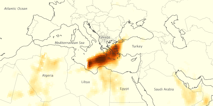
The Ozone Mapping Profiler Suite (OMPS) on the Suomi NPP satellite provided a different view of the storm (below). Airborne aerosol concentrations are represented by a quantity known as the aerosol index. High concentrations are represented with shades of deep red; the lowest concentrations are shades of light yellow.

It's typical to see high concentrations of dust in the atmosphere near the point where a storm originated, according to NASA atmospheric scientist Colin Seftor. However, dust in this storm retained high concentrations out into the Mediterranean. It's "quite unusual" to have such high values this far from the source, he said.
The timing of the storm was also unusual. "Such intense dust storms over the Mediterranean are most common in spring, so this is clearly early for the season," said Karlsruhe Institute of Technology meteorologist Peter Knippertz.
According to Knippertz, the dust storm appeared to be provoked by a cyclone that crossed Africa's Atlas Mountains. The cyclone's trailing cold front caused intense uplift, and then the dust plume moved northeast toward Turkey. “The cyclone itself was not unusual,” he said, “but the length, intensity, and southern position of the cold front were.”
NASA image by Jeff Schmaltz, LANCE/EOSDIS Rapid Response. Caption by Kathryn Hansen