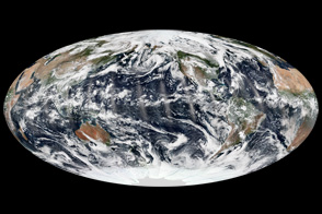

The basins are roughly 180 degrees apart, and in 2013, so were the tropical cyclone seasons. While the Atlantic hurricane season was remarkably quiet and mostly uneventful, the typhoon season was active and intense in the Western Pacific Ocean, though not necessarily out of character for the region.
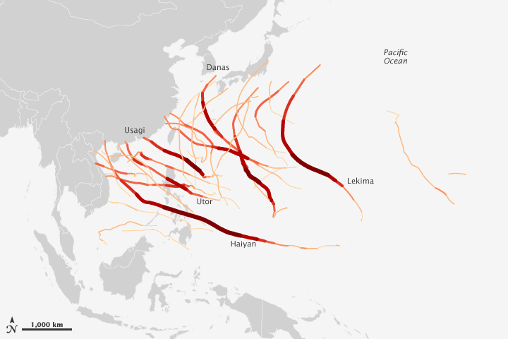
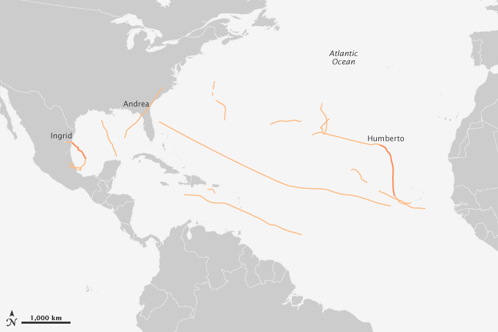
The maps above show the tracks and intensity of the tropical storms in both basins this year. The color and width of each line reflects the intensity of the storm on each day of its activity.
In the Atlantic, 13 tropical storms were observed (plus one tropical depression), with just two developing into hurricanes—the fewest since 1982. None of the storms became major hurricanes, the first time that has happened since 1994. The U.S. National Weather Service ranked 2013 as “the sixth-least-active Atlantic hurricane season since 1950.”
“This unexpectedly low activity is linked to an unpredictable atmospheric pattern that prevented the growth of storms by producing exceptionally dry, sinking air and strong vertical wind shear in much of the main hurricane formation region,” said Gerry Bell, lead seasonal hurricane forecaster at NOAA’s Climate Prediction Center. “Also detrimental were several strong outbreaks of dry and stable air that originated over Africa.”
In the Western Pacific in 2013, there were between 28 and 31 tropical storms, and 13 to 16 typhoons—six of which reached super typhoon strength. (Note: different institutions, including the Joint Typhoon Warning Center and the Japanese Meteorological Agency, have arrived at slightly different counts for the region.) According to the Tropical Storm Risk Consortium, the average is 26 tropical storms and 16 typhoons. The most active Western Pacific typhoon season was 1964 with 39 tropical storms.
Nearly one third of the world’s tropical storms form in the Western Pacific in any given year. “The Western Pacific is the world’s largest breeding ground of tropical cyclones, and storms tend to be larger and more intense there,” said research meteorologist Jeff Halverson of the University of Maryland, Baltimore County. This is because the sea surface temperatures are among the warmest in the world; the mixed layer of the ocean is deeper; there are fewer land barriers; and the tropopause—the boundary between the lower atmosphere and the stratosphere—is very high and cold. Essentially, storms have more fuel and more room (horizontally and vertically) to grow in the Western Pacific.
Sitting near the equator on the edge of those warm waters, the Philippine Islands are affected each year by roughly ten typhoons, five to six tropical storms, and four tropical depressions. Trade and monsoon winds tend to steer storms toward the archipelago. In 2013, several storms passed through the Philippines, bringing repeated and devastating rainfall that is depicted in this new animation from scientists at NASA’s Goddard Space Flight Center.
“The heaviest typhoon traffic in the Western Pacific is just to the northeast of the Philippines,” said Bill Patzert, a climatologist at NASA’s Jet Propulsion Laboratory. “For land-impacting typhoons, the Philippines is the bullseye.”
NASA Earth Observatory images by Jesse Allen and Robert Simmon. Caption by Mike Carlowicz, with reporting help from Bill Patzert, JPL; Jeff Masters, Weather Underground; Rob Gutro, NASA Goddard; and Jeff Halverson, UMBC.