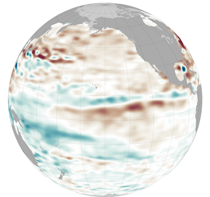


New data acquired in August 2013 show near-normal sea-surface height conditions across the equatorial Pacific Ocean. This neutral or “La Nada” pattern has stubbornly persisted since spring 2012. According to models run by the National Weather Service’s Climate Prediction Center, this pattern will likely continue through spring 2014.
“Without an El Niño or La Niña signal present, other less predictable climatic factors will govern fall, winter, and spring weather conditions,” said climatologist Bill Patzert of NASA’s Jet Propulsion Laboratory. “Long-range forecasts are most successful during El Niño and La Niña episodes. The in-between ocean state, La Nada, is the dominant condition and it is frustrating for long-range forecasters. It’s like driving without a decent road map.”
Based on data from NASA’s Jason 2 satellite, the map above shows a 10-day average of sea-surface height centered on August 27, 2013. Shades of red indicate where the water is relatively warmer and above normal sea level. Shades of blue show where sea level and temperatures are lower than average. Normal sea-level conditions appear in white.
The height of sea water is an indicator of the amount of heat stored in the ocean below. As the ocean warms, its level rises; as it cools, its level falls. Above-normal height variations along the equatorial Pacific indicate El Niño conditions, while below-normal height variations indicate La Niña conditions. (You can see an example of La Niña here and El Niño here.)
The temperature of the upper ocean can have a significant influence on weather patterns and climate; these processes are known as the inter-annual ocean signal. For the past several decades, about half of all years have experienced La Nada conditions, compared to about 20 percent for El Niño and 30 percent for La Niña. Some of the wettest and driest winters occur during La Nada periods.
“Neutral infers something benign. But if you look at these La Nada years, they can be the most volatile and punishing,” Patzert said. “As an example, the continuing, deepening drought in the American West is far from neutral.”
The comings and goings of El Niño, La Niña, and La Nada are part of the long-term, evolving state of global climate, for which measurements of sea surface height are a key indicator. Jason-2 is a joint effort between NASA, the National Oceanic and Atmospheric Administration (NOAA), the French Centre National d'Etudes Spatiales (CNES), and the European Organisation for the Exploitation of Meteorological Satellites (EUMETSAT). In early 2015, NASA and its international partners will launch Jason-3, which will extend the timeline of ocean surface topography measurements begun by the Topex/Poseidon and Jason 1 and 2 satellites.
NASA Earth Observatory image by Jesse Allen and Kevin Ward, using JASON-2 data provided by Akiko Hayashi, NASA/JPL Ocean Topography Team. Caption by Alan Buis, JPL.