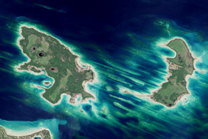
The Great Sandy Strait is an estuary that separates the mainland coastline of the state of Queensland, Australia, from neighboring Fraser Island. The mainland side of the Strait includes the city of Hervey Bay. The communities of Scarness, Booral, and Urangan are also part of the larger metropolitan area.
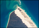
A small, vegetated island and shallow sand bars of the Great Sandy Strait are visible in this astronaut photograph from the International Space Station. A small, bright white exposure of sand is visible above the water level near the center of the image, while submerged sands appear as flowing, bright blue ribbons.
Hervey Bay was once a major freighting center for the sugar cane industry, but now the local economy is largely based on tourism, with whale watching a popular attraction. The estuary provides habitat for breeding fish, crustaceans, turtles, and other sea life, as well as a wide variety of birds—including wading species such as Eastern Curlews, Bat-tailed Godwits, and Pied Oystercatchers. Nearby Fraser Island is the world’s largest sand island and a World Heritage site.
Astronaut photograph ISS036-E-28444 was acquired on August 3, 2013, with a Nikon D3S digital camera using a 400 millimeter lens, and is provided by the ISS Crew Earth Observations experiment and Image Science & Analysis Laboratory, Johnson Space Center. The image was taken by the Expedition 36 crew. It has been cropped and enhanced to improve contrast, and lens artifacts have been removed. The International Space Station Program supports the laboratory as part of the ISS National Lab to help astronauts take pictures of Earth that will be of the greatest value to scientists and the public, and to make those images freely available on the Internet. Additional images taken by astronauts and cosmonauts can be viewed at the NASA/JSC Gateway to Astronaut Photography of Earth. Caption by William L. Stefanov, Jacobs at NASA-JSC.