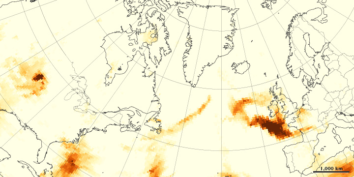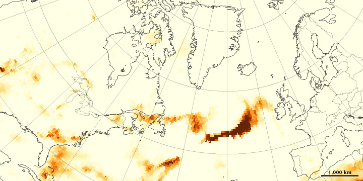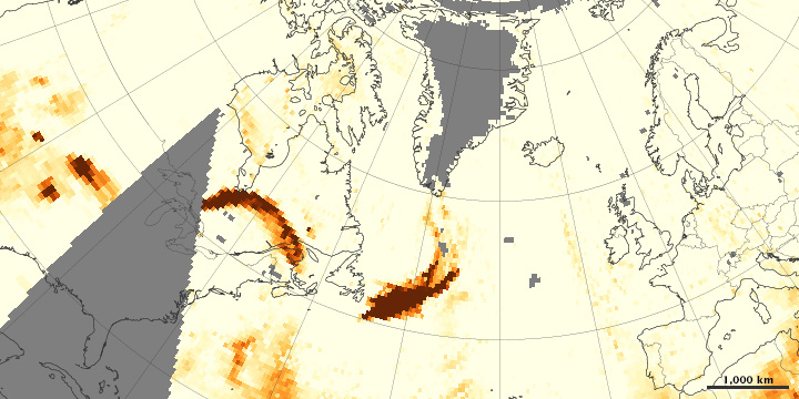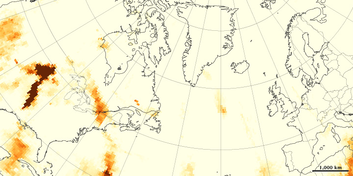


Intense wildfires in Quebec sent smoke billowing out of Canada at the end of June 2013. The fires produced towering pyrocumulus clouds that injected smoke high into the atmosphere. Upper-level winds then dispersed it across the Atlantic Ocean.
Wildfire smoke is a combination of gases and aerosols—tiny solid and liquid particles suspended in air—so remote-sensing instruments that detect aerosols can find smoke. The maps above are made from data collected by the Ozone Mapper Profiler Suite (OMPS) on the Suomi National Polar-orbiting Partnership (Suomi-NPP) satellite. They show relative aerosol concentrations, with lower concentrations appearing in yellow and higher concentrations appearing in dark orange-brown. Areas in gray represent data that was not available.
On June 23, 2013, OMPS detected a plume dense with smoky aerosols over the North Atlantic Ocean, east of Newfoundland. The plume blew east on the 24th and reached France by June 25. While wildfires in Colorado may have contributed to the plume (notice the heavy smoke over Colorado on June 22), a trajectory analysis by Alain Malo, a meteorologist from the Meteorological Service of Canada, suggests that much of the smoke actually came from Quebec.
The ambiguity explains why remote sensing scientists rarely use just one sensor to analyze smoke transport events like this. It is common for plumes of wildfire smoke to cross the Atlantic, and scientist use several satellite sensors to observe the process. But each sensor has strengths and weaknesses, explained Hongbin Yu, a University of Maryland scientist who recently authored an analysis of satellite observations of aerosol transport events between continents.
OMPS measurements can be affected by the height of the plume and by the brightness of underlying clouds; OMPS sees higher plumes more readily than lower plumes, and bright underlying clouds can cause aerosol values to be appear artificially high. Because they offer a “semi-quantitative” measure of aerosol loading OMPS’s aerosol measurements can sometimes be difficult to interpret.
On the other hand, “unlike MODIS and MISR, OMPS is not limited to cloud-free conditions, so it provides more complete plume tracking,” Yu explained. The most comprehensive approach to monitoring intercontinental smoke transport is to use MISR to observe smoke injection height near source fires, OMPS to track plumes over long distances, MODIS to measure aerosol loading, and CALIOP to capture a vertical profiles of smoke plumes.
NASA Earth Observatory images by Jesse Allen, using OMPS research data provided courtesy of Colin Seftor (SSAI) and NASA’s Suomi NPP Ozone Science Team. Caption by Adam Voiland.