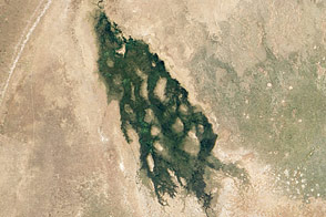
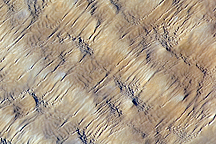
In southwestern Egypt, deep in the Sahara Desert, the wind dominates the shape of the landscape, as it has done for the past several thousand years. Winds blowing from the north have fashioned sands into large dunes, aligned parallel with these winds.
The so-called linear dunes—shown here in the Great Sand Sea of southwest Egypt—are easily spotted from space, and local maps show that they rise 20 to 30 meters above the surrounding plains. The distance between dunes is interestingly regular, at 1.5 to 2.5 kilometers, suggesting some equilibrium exists between the wind strength and the sand supply. It is possible that the linear dunes are a reflection of earlier times, when winds were stronger or sand more plentiful.
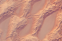
The dark rock outcrops at image lower left stand above the surface by as much as 150 meters. North winds have been deflected around this high zone, and smaller secondary linear dunes appear along the left side of the image, aligned with local winds that become ever more northeasterly as they approach the outcrops. A dune-free zone on the protected downwind (south-southeast) side of the outcrop gives a sense of the sand movement.
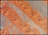
At first glance, the large linear dunes appear to be the major landform in the image; however, a complex pattern of even smaller dunes can be seen on top of the largest dunes (inset). It is not uncommon to observe multiple dune forms in large sand seas, as in the Marzuq Sand Sea, the Ar Rub' Al Khali, and the Tenere Desert.
The sand in many dune fields usually derives from some larger river not very distant upwind; often it comes from a dry river bed that gets exposed to wind during dry seasons, or from a low-flow river that changed due to a more arid regional climate. Inland dune fields thus lie downwind of the source river. West of the dunes shown in this photograph, a large, unnamed river once flowed to the Mediterranean Sea and dumped its sand load 300 kilometers northwest of the area shown. It is likely that this river—evidence of which is now almost completely obliterated—was the source of the sand in the linear dunes.
Astronaut photograph ISS031-E-30783 was acquired on May 11, 2012, with a Nikon D2Xs digital camera using a 180 mm lens, and is provided by the ISS Crew Earth Observations experiment and Image Science & Analysis Laboratory, Johnson Space Center. The image was taken by the Expedition 31 crew. It has been cropped and enhanced to improve contrast, and lens artifacts have been removed. The International Space Station Program supports the laboratory as part of the ISS National Lab to help astronauts take pictures of Earth that will be of the greatest value to scientists and the public, and to make those images freely available on the Internet. Additional images taken by astronauts and cosmonauts can be viewed at the NASA/JSC Gateway to Astronaut Photography of Earth. Caption by M. Justin Wilkinson, Jacobs/ESCG at NASA-JSC.