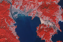
When the monstrous tsunami of March 2011 struck the northeast coast of Japan, the retreating waves pulled many pieces of civilization and many lives out to sea. The Japanese government estimated that 5 million tons of debris was swept up by the event, with about 70 percent sinking to the seafloor and 1.5 million tons left floating. More than a year later, the debris from that tragedy is still drifting on the Pacific Ocean, though no one can say for sure how much and where.
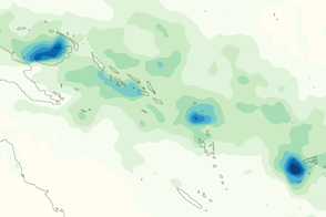
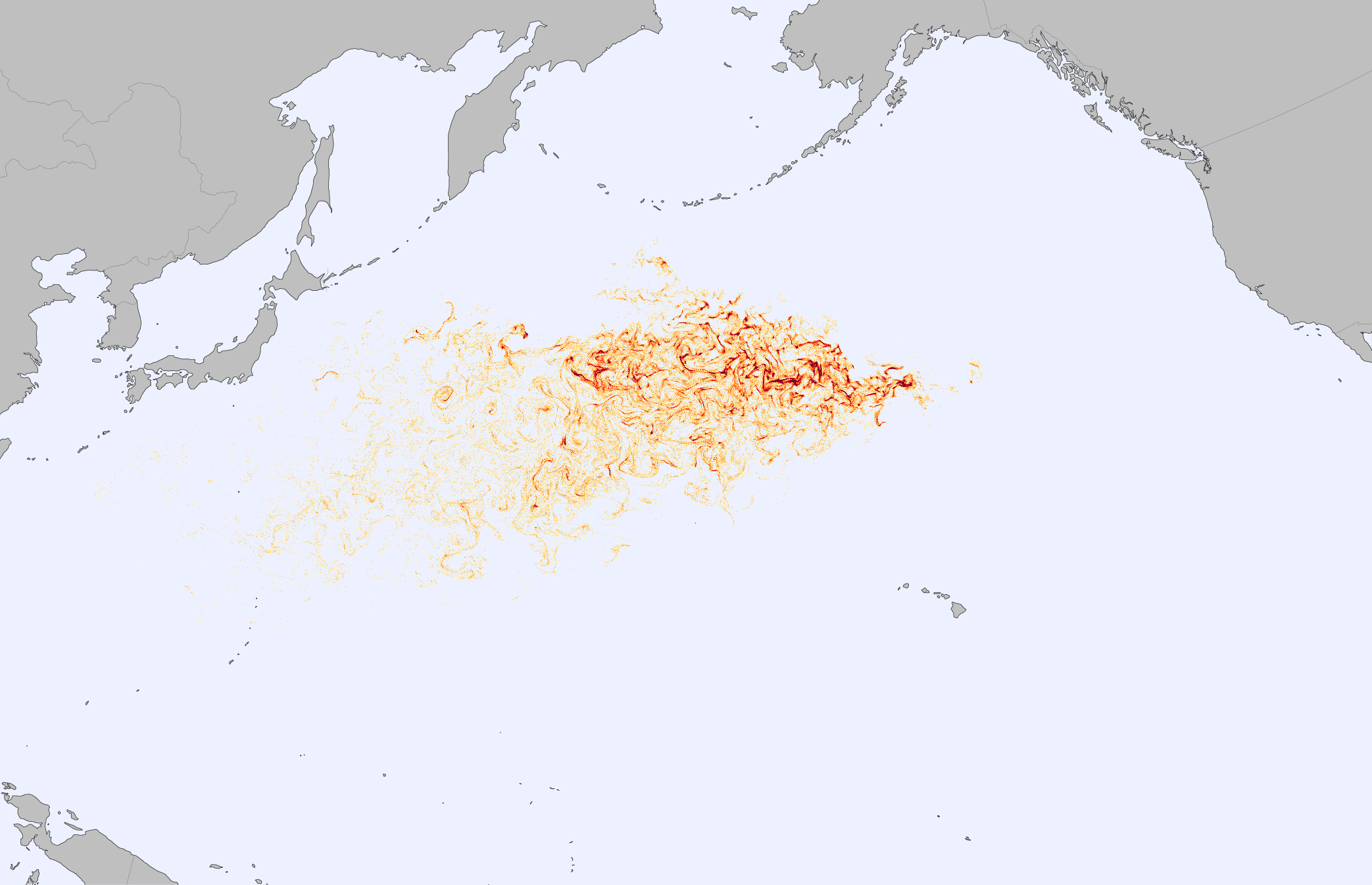
The map above shows the output of the Surface Currents from Diagnostic (SCUD) model, an attempt to simulate where and how that debris would disperse. Orange and red shaded areas represent parcels of water with a high probably of containing floating debris. The deeper the red color, the higher the likely concentration. The debris field stretches roughly 5,000 kilometers by 2,000 kilometers across the North Pacific.
The model begins with more than 678,000 “tracers” being released from various points along the northeastern coast of Japan on March 11, 2011. The initial distribution is based on the density of population and development. The still image above shows the predicted distribution of debris by April 3, 2012. Click on the downloadable animation (linked below the image) to see the motion over time.
The SCUD model was developed by Nikolai Maximenko and Jan Hafner of the International Pacific Research Center (IPRC) at the University of Hawaii. Using real satellite data on sea surface height and on ocean surface winds—as well as information from scientific drifting buoy networks—the IPRC team makes daily maps of surface currents. Hafner and Maximenko have also collected reports of debris sightings in the ocean, which have so far validated what the model tells them.
Debris was initially carried by the potent Kuroshio Current, which whips past eastern Japan much like the Gulf Stream in the North Atlantic. The Kuroshio carries surface waters northeast, before eventually turning east in the Kuroshio Extension and then the North Pacific Current. Some debris should reach the west coast of North America within a year or two, while much of it is likely to end up in the floating debris field in the middle of the North Pacific Gyre that is referred to as “the garbage patch.”
As of April 3, 2012, there had been very few reports of debris at Midway Island and Kure Atoll. North winds have been minimal in recent months, and ocean currents have favored keeping the debris from the island. But those currents may be shifting, Hafner noted, and debris should eventually wash up with greater frequency.
Observers in Canada recently detected an abandoned 150-foot Japanese fishing vessel floating offshore of British Columbia. Other reports of debris in Washington and Hawaii came in months ago. But in most cases, the objects were larger and standing above the water line, where they could be pushed like sails at higher speeds. The model shown above tracks objects sitting at or just below the water line.
NASA Earth Observatory image by Jesse Allen, using model data courtesy of Jan Hafner, International Pacific Research Center. Caption by Michael Carlowicz.