

There is no getting around the fact that the Earth is a crowded planet. It can be difficult for a population of nearly 6.6 billion people (as of May 16, 2007) to figure out how to share key natural resources, such as water and fertile land, with one another. It is often even harder for humans to figure out how to share those resources with the planet’s other inhabitants. Often, decisions that seem to be good for immediate human needs are detrimental for other life. Worldwide, no terrestrial ecosystem is disappearing more rapidly than wetlands, according to United Nations Millennium Ecosystem Assessment Synthesis Report on Wetlands and Water.
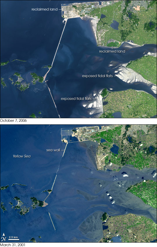
This pair of images from the Advanced Spaceborne Thermal Emission and Reflection Radiometer (ASTER) on NASA’s Terra satellite illustrates the beginning stages of a land reclamation project in South Korea that will transform one of the largest tidal estuaries on the coast of the Yellow Sea—an important habitat for migratory birds, fish, and shellfish—into farmland and a fresh-water reservoir over the next ten years. The government’s construction of a 33-kilometer-long sea wall, completed in April 2006, around the Saemangeum estuary and wetlands has begun to expose the tidal flats at the mouth of the rivers. The ghostly shapes of the submerged tidal flats were visible just below the water’s surface in 2001, while in 2006, they were high and dry, standing out in bright white against the blue water. Other pockets of coastal land had also been filled and appear to have been developed or planted between March 31, 2001 (bottom) and October 7, 2006 (top). A view of the area in 1989, before seawall construction began, is provided via the large image links above.
The draining and filling of the estuary will ultimately add more than 400 square kilometers (155 square miles) of land to the country’s coast, but it will be a major habitat loss for hundreds of thousands of migratory birds that alight there each year to rest and refuel on their long journeys to and from breeding and wintering sites in opposite hemispheres. Concerns about wildlife, the fate of the coastal fishing industry, and water pollution kept the project tied up in lawsuits for more than a decade, but in February 2006, South Korea’s Supreme Court ruled in favor of the government, and the final construction to close the sea wall was finished in April 2006.
You can download a 15-meter-resolution Saemangeum KMZ file for use with Google Earth.
NASA image created by Jesse Allen, using data provided courtesy of the NASA/GSFC/MITI/ERSDAC/JAROS, and U.S./Japan ASTER Science Team.