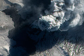
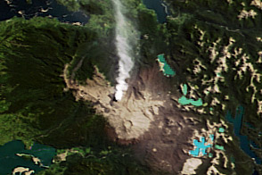
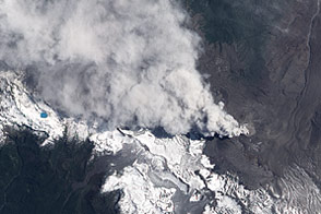
In early June 2011, Chile’s Puyehue-Cordón Caulle Volcano erupted explosively, sending volcanic ash around the Southern Hemisphere. In late December 2011, activity at the volcano had calmed, but volcanic ash and steam continued to pour through the fissure that opened several months earlier.
The Advanced Land Imager (ALI) on NASA’s Earth Observing-1 (EO-1) satellite captured this natural-color image on December 23, 2011. The active fissure lies northwest of the Puyehue caldera, and a plume blows from the fissure toward the west and north. This image shows not just ash but also snow on the volcano surface, including the caldera. Because volcanic ash regularly coats the land surface, the pristine snow probably fell recently.
In a bulletin issued December 26, 2011, Chile’s Servicio Nacional de Geología y Minería (SERNAGEOMIN) characterized the activity over the previous 24 hours as a minor eruption of low intensity.
Reaching an altitude of 2,236 meters (7,336 feet), Puyehue-Cordón Caulle is a stratovolcano, a steep-sloped, conical volcano composed of layers of ash, lava, and rocks released by previous eruptions. This volcano comprises part of the largest active geothermal area in the southern Andes.
NASA Earth Observatory image created by Jesse Allen, using EO-1 ALI data provided courtesy of the NASA EO-1 team. Caption by Michon Scott.
Image of the Day Land Volcanoes
Acquired in late December 2011, this image shows a volcanic plume pouring out of a fissure on the slope of Chile’s Puyehue-Cordón Caulle Volcano.
Image of the Day for December 30, 2011
View more Images of the Day:

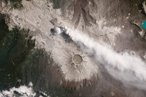
Chile's Puyehue-Cordón Caulle Volcano erupted on June 4, 2011, and continued until April 2012. The effects of the eruption continue to be felt in the region.
alert message