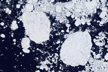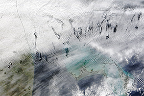
On January 29, 2007, inhabitants of Acadiana, the Cajun heartland in southern Louisiana, saw unusual looking cloud formations. These “hole punch” clouds were just as apparent from above as they were from below. This pair of images shows the hole-punch clouds captured by the Moderate Resolution Imaging Spectroradiometer (MODIS) on NASA’s Terra satellite (top) and from the ground (bottom). The MODIS image shows a number of round holes in a blanket of cloud cover over Oklahoma, Arkansas, Louisiana, and Texas. A few of the “holes” are elongated, with what appear to be smaller clouds inside them.
This strange phenomenon resulted from a combination of cold temperatures, air traffic, and perhaps unusual atmospheric stability. The cloud blanket on January 29 consisted of supercooled clouds. Supercooled clouds contain water droplets that remain liquid even though the temperature is well below freezing, and such clouds are not unusual. According to the Cooperative Institute for Meteorological Satellite Studies (CIMSS) Satellite Blog, cloud-top temperatures ranged from 20 to 35 degrees Celsius. As aircraft from the Dallas-Fort Worth airport passed through these clouds, tiny particles in the exhaust came into contact with the supercooled water droplets, which froze instantly. The larger ice crystals fell out of the cloud deck, leaving behind the “holes,” while the tiniest ice particles in the center remained aloft.
The people on the ground watching the show these clouds made didn’t have to worry about getting wet or being showered with ice. When the general atmospheric conditions aren’t favorable for rain, the falling ice crystals sublimate—change state directly from a solid to a gas—as they pass through warmer layers of the atmosphere.
NASA image by Jeff Schmaltz, MODIS Rapid Response Team, Goddard Space Flight Center. Photograph © 2007 yesitspuzzling. Thanks to J. Marshall Shepherd, University of Georgia, for image interpretation.