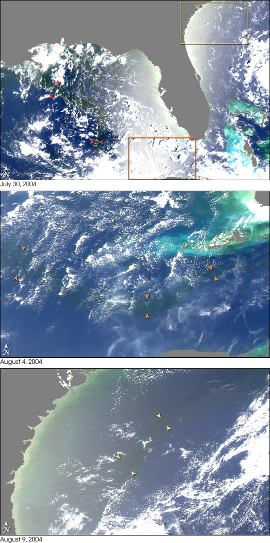


Freshwater flowing off the land surface into the ocean is rich in nutrients and organic matter that influence the biology of the ocean—everything from seagrasses, to coral reefs, to single-celled ocean plants called phytoplankton. In terms of freshwater flow, the Mississippi River is the United States’ major contributor, draining over 40 percent of the U.S. land surface and ranking 8th in the world in terms of volume of water discharged to the ocean. But what happens to the water when it enters the Gulf of Mexico?
In the summer months, a large portion of the Mississippi River outflow heads southeast into the Gulf of Mexico. In summer 2004, scientists combined satellite images of the Gulf of Mexico and the Atlantic Ocean with ship-based measurements of salt content and water chemistry to track the spread of a large plume of Mississippi River freshwater into the Gulf of Mexico and beyond. The Moderate Resolution Imaging Spectroradiometer (MODIS) images shown here follow the freshwater plume in late July and early August. The freshwater from the Mississippi appears as a dark ribbon against the lighter-blue surrounding waters.
The images demonstrate that the plume did not mix with the surrounding sea water immediately. Instead, it stayed intact as it flowed through the Gulf of Mexico, into the Straits of Florida, and entered the Gulf Stream. The Mississippi River water rounded the tip of Florida and traveled up the Southeast coast to the latitude of Georgia before finally mixing in so thoroughly with the ocean that it could no longer be detected by MODIS. The images were captured by the MODIS on NASA’s Aqua satellite on (top to bottom) July 30, August 4, and August 9.
NASA image by Jesse Allen