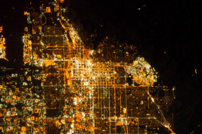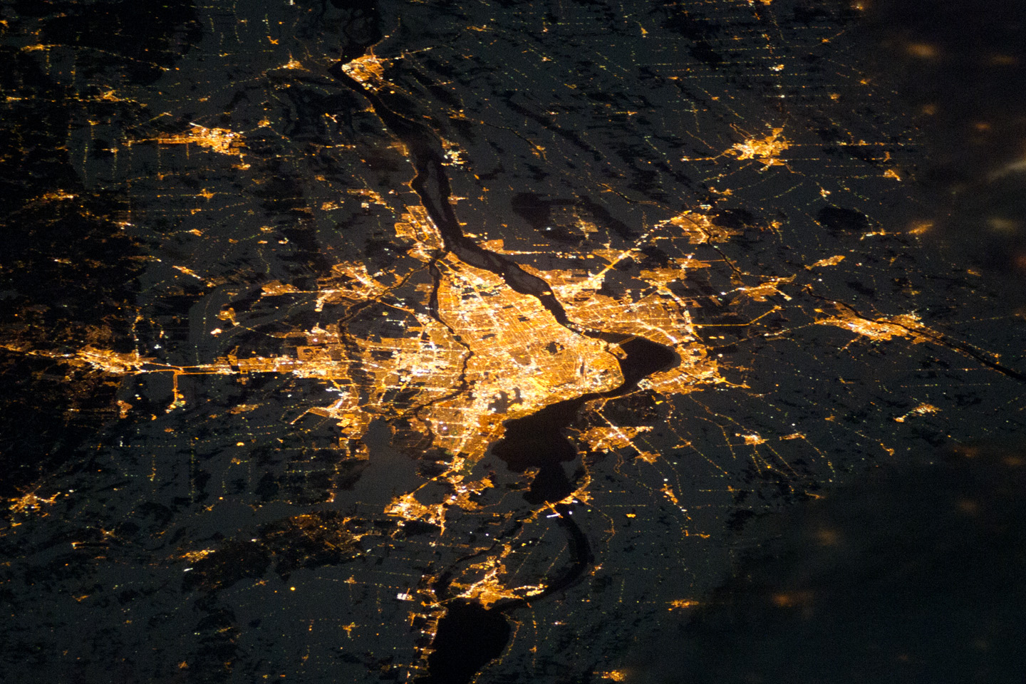
Montreal, the largest city in the mostly French-speaking Province of Quebec, is considered by some to be the cultural capital of Canada. The metropolitan area (image center) is the country’s second-largest, having been surpassed by Toronto in 1976. While the city of Montreal is located on the Island of Montreal, at the confluence of the St. Lawrence (image center) and Ottawa rivers (not visible), the city takes its name from Mont Royal, located at the city’s center. Several smaller urban areas form a loose ring around the metropolitan area: Sorel-Tracy, Saint-Hyacinthe, Saint-Jean-sur-Richelieu, Salaberry-de-Valleyfield, Saint-Jerome, and Joliette are among those that can be readily identified.
This astronaut photograph of the city lights of Montreal illustrates the extent of urbanization. Major roadways and industrial areas are traced by bright white lighting, while the adjacent residential and commercial lands are characterized by more diffuse yellow-gold lighting. Rivers and other water bodies appear black, while the surrounding countryside is faintly illuminated by moonlight. Blurry areas at image top and bottom right are caused by cloud cover.
The International Space Station was located over the Pennsylvania-New York border (near Warren, Pa.) at the time this image was taken—a ground distance of approximately 600 kilometers (370 miles) southwest of Montreal. This distance from the camera target, coupled with the oblique (inclined) viewing angle from the ISS, results in the foreshortened appearance of urban areas in the image.
Astronaut photograph ISS026-E-12474 was acquired on December 24, 2010, with a Nikon D3S digital camera using a 180 mm lens, and is provided by the ISS Crew Earth Observations experiment and Image Science & Analysis Laboratory, Johnson Space Center. The image was taken by the Expedition 26 crew. The image has been cropped and enhanced to improve contrast. Lens artifacts have been removed. The International Space Station Program supports the laboratory as part of the ISS National Lab to help astronauts take pictures of Earth that will be of the greatest value to scientists and the public, and to make those images freely available on the Internet. Additional images taken by astronauts and cosmonauts can be viewed at the NASA/JSC Gateway to Astronaut Photography of Earth. Caption by William L. Stefanov, NASA-JSC.