For most of us, knowing how much water we use is a simple matter of opening the bill that arrives in the mail every month, but state and regional water managers have a far greater challenge. For water managers, water is used only when it is permanently removed from the ground or rivers. The water we use in our houses goes through the sewer and a treatment facility and back into a river or the ground where it can be re-used. For a water manager, the only time water is consumed is when it evaporates into the air or is soaked up by plants and then turned into water vapor (transpiration). Under this definition, measuring water use comes down to measuring evaporation and transpiration, or evapotranspiration.
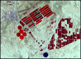
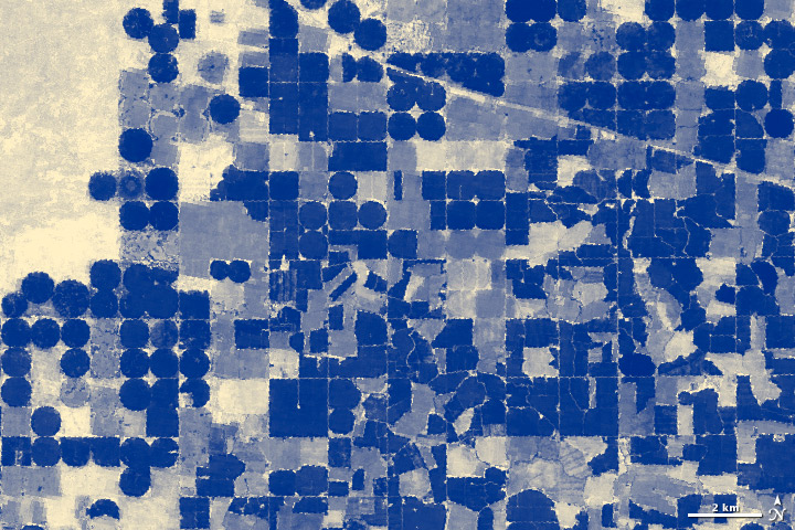
Because satellites see a wide area at once, they are ideal tools for monitoring evapotranspiration. This image, based on data collected by the Landsat 5 satellite on August 9, 2006, shows evapotranspiration from vegetation on the Snake River Plain in south-central Idaho. Fields of irrigated crops are dark blue squares or circles, showing that the growing plants are taking up and transpiring water. Fallow and recently harvested fields are lighter blue. Surviving on the scant rain that falls on the high desert, the surrounding natural scrubland uses far less water. The scrubland, shown in the upper left corner of the image, is tan and pale blue. The diagonal line across the upper right corner of the image is a road.
The image was created with a model that combines Landsat measurements of surface temperature and vegetation with weather data to estimate how much water is entering the atmosphere through evapotranspiration. The Idaho Department of Water Resources uses the model as a relatively inexpensive way to monitor water use on the 3.4 million acres of farmland that provide the economic base for the state.
To read more about how satellite data are contributing to water management in Idaho, please see Water Watchers on the Earth Observatory.
NASA image by Robert Simmon, based on data from the Idaho Department of Water Resources. Caption by Holli Riebeek.