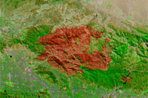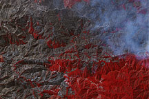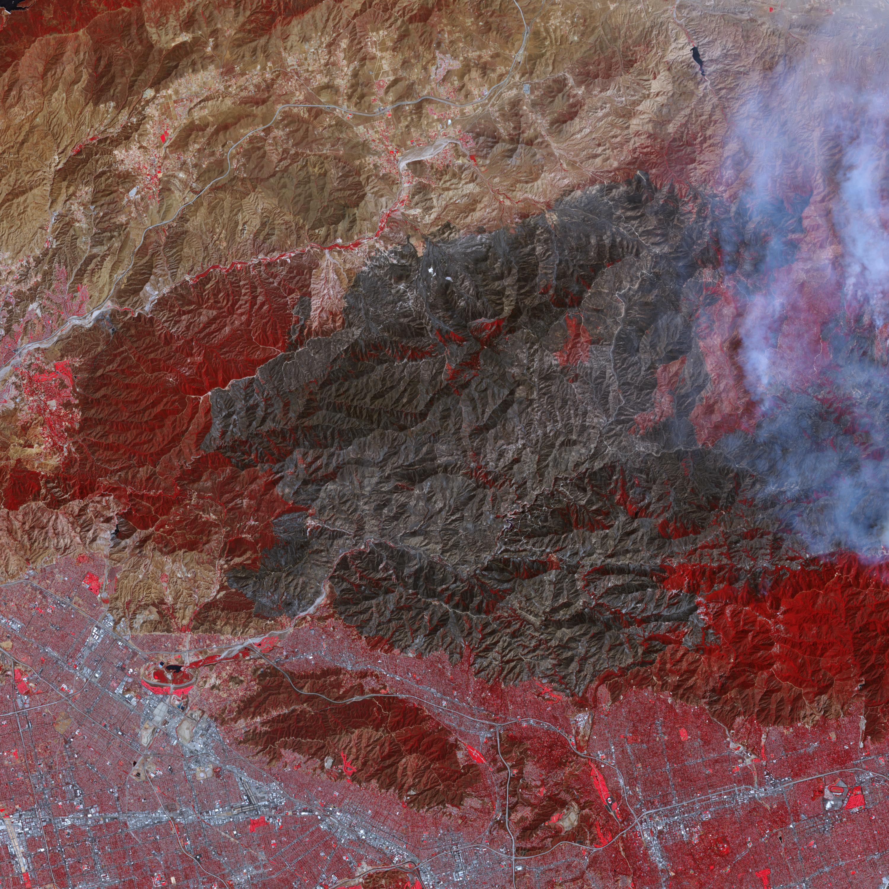
Two weeks after an arsonist ignited the drought-dry forest north of Los Angeles, the Station fire had become the ninth largest fire in California since 1933. On the morning of September 8, 2009, the fire had burned more than 250 square miles (about 650 square kilometers) of land, according to the Station Fire Incident Report from September 8. This image, captured by the Advanced Spaceborne Thermal Emission and Reflection Radiometer (ASTER) on NASA’s Terra satellite on September 6, shows the extent of the burned area. The newly charred land is black in this false-color image, which was made with near infrared light. Plants are dark red, and man-made surfaces, particularly the dense urban centers of Pasadena and Burbank, are blue and white.
The burned area covers much of the San Gabriel Mountains, edging down into residential areas northwest of Pasadena. Smoke rolls off the eastern edge of the burned land. The fire was still burning, just over 50 percent contained when the image was taken. According to the incident report from September 8, the fire was pushing east into forest with no recorded fire history. The fire had previously burned through tall, thick forest that had not seen fire in the past 40 years.
The image also illustrates why fighting the Station fire has been so difficult. The fire burned over steep mountains riddled with canyons. The rugged landscape looks wrinkled, particularly in the burned area where plants no longer soften the ridgelines and canyons. The steep terrain and the fire’s extreme, unpredictable behavior led to the death of two firefighters. Nine other firefighters have been injured fighting the fire, reported the Los Angeles Times.
South and east of the fire, the Mount Wilson Communication Facility and Observatory was still surrounded by unburned forest. The historic, 105-year-old observatory hosts two large telescopes, once the world’s largest, and other instruments to study the Sun and the Universe beyond. Mount Wilson also contains communications towers that serve much of the Los Angeles region. The image shows that the fire approached the facility on two sides, but left the forest around the observatory intact.
NASA image created by Jesse Allen, using data provided courtesy of NASA/GSFC/METI/ERSDAC/JAROS, and U.S./Japan ASTER Science Team. Caption by Holli Riebeek.