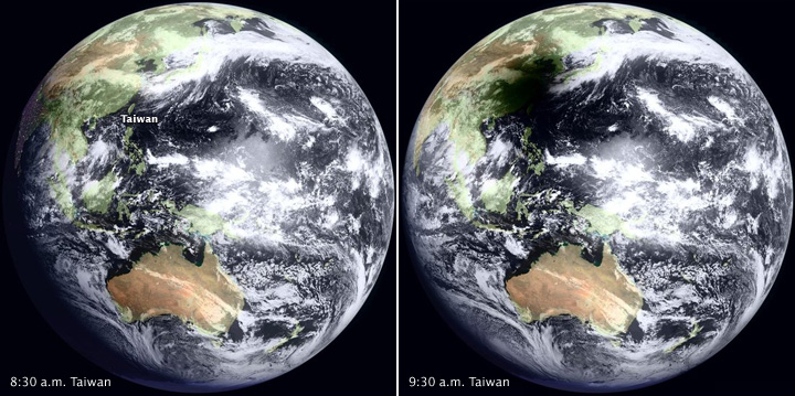


The Moon’s shadow engulfed Taiwan and a large swath of southeastern China and the Pacific Ocean on the morning of July 22, 2009, during an unusually long total eclipse of the Sun. This pair of images from the Japanese geostationary satellite MTSAT show the view of Earth at 8:30 a.m. local time in Taiwan (left) and an hour later (right), near the time in eastern China when the disk of the Moon completely overlapped the disk of the Sun (called totality). The longest period of totality occurred over the Pacific, where the total eclipse lasted more than 6 minutes.
These images combine current “daytime” data observed by MTSAT during the eclipse with a static background image of city lights for the “nighttime” portion of the globe. [Geostationary satellites don’t have the sensitivity or spatial resolution to detect urban lights at night.] The night lights background is part of the NASA Blue Marble image collection, developed by the Earth Observatory Team in cooperation with scientists from NASA Goddard Space Flight Center and the National Oceanic and Atmospheric Administration (NOAA).
Images provided by WebGMS–MTSAT/GMS (HIMAWARI) Website, Institute of Industrial Science & Earthquake Research Institute, University of Tokyo, Japan.