
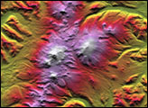
Russia’s Kamchatka Peninsula, lying between the Sea of Okhotsk to the west and the Bering Sea and Pacific Ocean to the east, is one of the most active volcanic regions along the Pacific Ring of Fire. It covers an area about the size of Colorado but contains more than 100 volcanoes stretching across the 1000-kilometer-long (620-mile-long) land mass. A dozen or more of these have active vents, with the youngest located along the eastern half of the peninsula. This color-coded shaded relief image, generated with data from the Shuttle Radar Topography Mission (SRTM), shows Kamchatka’s volcanic nature to dramatic effect.
Kliuchevskoi, one of the most active and renowned volcanoes in the world, dominates the main cluster of volcanoes called the Kliuchi group, visible as a circular feature in the center-right of the image. The two other main volcanic ranges lie along northeast-southwest lines, with the older, less active range occupying the center and western half of Kamchatka. The younger, more active belt begins at the southernmost point of the peninsula and continues upward along the Pacific coastline.
Two visualization methods were combined to produce this image: shading and color coding of topographic height. The shade image was derived by computing topographic slope in the north-south direction, so northern slopes appear bright and southern slopes appear dark. Color coding is directly related to topographic height, with green at the lower elevations, rising through yellow and brown to white at the highest elevations.
Size: 1,113 by 638 kilometers (692 by 396 miles)
Location: 55 degrees North latitude, 160 degrees East longitude
Orientation: North toward the top
Image Data: Shaded and colored SRTM elevation model
Date Acquired: February 2000
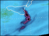
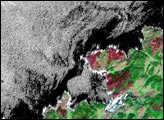
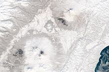
Photographs from the Space Shuttle and International Space Station show a different perspective on the volcanoes of cental Kamchatka.
Image Courtesy SRTM Team NASA/JPL/NIMA

