The Earth Observatory has published its last Image of the Day on this website. Please join us on our new home at science.nasa.gov/earth/earth-observatory.
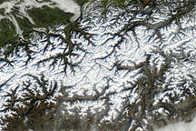
The Bernese Alps form the centerpiece of this late summer view of Switzerland; Jungfrau (J—4158 m), Moench (M—4089 m), and Eiger (E—3970 m) are among the higher peaks of the Central Alps. North of the range is the city of Interlaken, flanked by the Thune See and Brienzer See (lakes); the long, straight-segmented valley of the Rhone lies to the south.
On the southern flank of the Jungfrau massif is the Aletsch glacier, meltwaters of which feed the upper Rhone; another source is the Rhone glacier at the eastern end of the valley. One estimate holds that roughly half the ice in glaciers of the European Alps has melted since 1850. U-shaped valleys carved by glaciers are clearly visible; some, such as that of the Rhone, have been modified by through-flowing rivers.
The Swiss Alps are elements of a great mountain system that was constructed as Africa and Eurasia collided, starting more than 90 million years ago. Ancient basement rocks (>325 million years old) of the Bernese Alps were uplifted, folded, and forced northward between ~29 and 10 million years ago.
STS106-718-09 was taken in September, 2001 by the crew of Space Shuttle mission 106 using a Hasselblad camera with 250-mm lens. The image is provided by the Earth Sciences and Image Analysis Laboratory at Johnson Space Center. Additional images taken by astronauts and cosmonauts can be viewed at the NASA-JSC Gateway to Astronaut Photography of Earth.