
Days of intense rainfall in August 2016 led to widespread flooding in southern Louisiana, as rivers swelled high above their banks and many crested at record-high levels. According to news reports, the floods prompted the rescue of at least 20,000 people and caused at least nine deaths. Louisiana’s governor declared a state of emergency on August 12 and a “major disaster” on August 14.
The animation above shows satellite-based measurements of the rainfall as it accumulated over the southern United States. Specifically, it shows rainfall totals every three hours over the span of 72 hours from August 12-14, 2016. These rainfall totals are regional, remotely-sensed estimates, and local amounts can be significantly higher when measured from the ground.
The data come from the Integrated Multi-Satellite Retrievals for GPM (IMERG), a product of the Global Precipitation Measurement mission. The GPM satellite is the core of a rainfall observatory that includes measurements from NASA, the Japan Aerospace Exploration Agency, and five other national and international partners.
According to Weather Underground, the multi-day rainfall accumulations (more than 20 inches in some places) stemmed from an unusual storm system. The low-pressure system developed a warm core, and counter-clockwise air flow pulled in moisture from warm waters in the Gulf of Mexico and the Atlantic Ocean. In that sense, the storm was similar to a tropical depression, except that surface winds were light.
The system was extremely slow moving. Over a seven-day period, rain totals in southern Louisiana were at least 600 percent of normal, according to the Lower Mississippi River Forecast Center of the U.S National Weather Service.

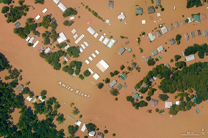
The second image shows some of the historic flooding. The photograph was acquired on August 14, 2016, with the Trimble Digital Sensor System (DSS), which was flown on an aerial photography mission conducted by the NOAA Remote Sensing Division. It shows flooded areas in Port Vincent, along a segment of the Amite River southeast of Baton Rouge. The photo was captured from an altitude of 1,500 meters (5,000 feet)—high enough to broadly survey the damage, but not so high that clouds block the view.
NASA Earth Observatory map by Joshua Stevens, using IMERG data provided courtesy of the Global Precipitation Mission (GPM) Science Team’s Precipitation Processing System (PPS). Photograph provided by the NOAA Remote Sensing Division. Caption by Kathryn Hansen.