

In October 2004, ecologist Steve Running visited the Flaming Mountain, a ridge of dark red sandstone on the edge of the Taklimakan Desert and the Tian Shan range. The surface of the mountain is said to reach temperatures of 50 to 80°C (122 to 175°F) in the summer, and a nearby tourist center marks the spot with a huge golden thermometer. It is the hottest place in China, if not the world, or so says the local lore.
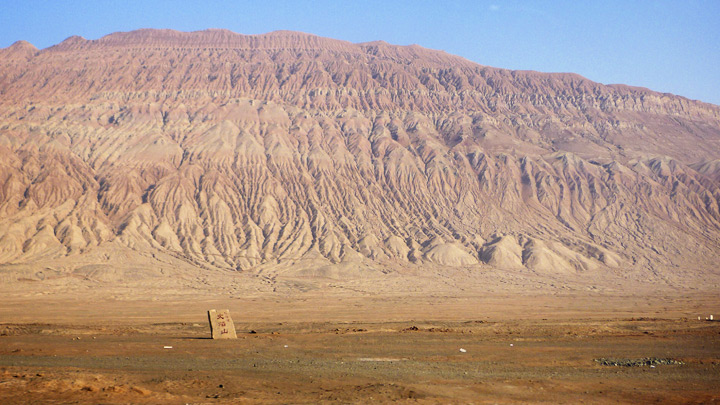
According to local lore, the Flaming Mountain is the hottest spot in China. After visiting the site, scientists used NASA data to find out for sure. (Photograph ©2011 oh contraire.)
And that got Running thinking: exactly where is the hottest place on Earth? With some colleagues at the University of Montana, he did some research and found that the location of the world’s hottest spot changes, though the conditions don’t. Think dry, rocky, and dark-colored lands.
In July 1913, observers in Furnace Creek, California—Death Valley—watched the thermometer reach 56.7°C (134°F) and declared it to be the highest temperature ever recorded on Earth. But just nine years later, on September 13, 1922, a weather station in El Azizia, Libya, recorded a temperature of 58.0°C (136.4°F). According to the World Meteorological Organization (WMO), that remains the highest air temperature ever measured.
“Yet most of the places that call themselves the hottest on Earth are not even serious contenders,” says Running. The reason is partly about where the measurements are made. But it is also a tale about how temperature is measured.
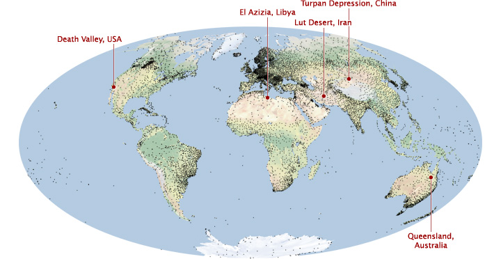
In the remote, sparsely populated areas that are likely to be the world’s hottest, weather stations (black dots) are widely spaced. Satellites provide a global view that can fill in the gaps. (Map by Robert Simmon, using data from the WMO & Natural Earth.)
“The World Meteorological Organization has approximately 11,119 weather stations on Earth’s land surface collecting surface temperature observations,” notes David Mildrexler, also from the University of Montana. “When compared to the 144.68 million square kilometers of land surface, that’s one station every 13,012 square kilometers.”
“The Earth’s hot deserts—such as the Sahara, the Gobi, the Sonoran, and the Lut—are climatically harsh and so remote that access for routine measurements and maintenance of a weather station is impractical,” he adds. “The majority of Earth’s hottest spots are simply not being directly measured by ground-based instruments.”
That’s where satellites come in.
For a dozen years, NASA has operated the Moderate Resolution Imaging Spectroradiometer (MODIS) on two different satellites; first on Terra (launched in 1999) and then on Aqua (2002). The instrument has 36 different spectral bands (groups of wavelengths) and many ways to view the planet. One of them is the detection of thermal radiance, or the amount of infrared energy emitted by the land surface. Since the two MODIS instruments scan the entire surface each day, they can provide a complete picture of earthly temperatures and fill in the gaps between the weather stations.
On the warmest summer days, you may hear someone say: “it’s a hundred degrees in the shade.” It’s an old-fashioned phrase with an unintended kernel of insight.
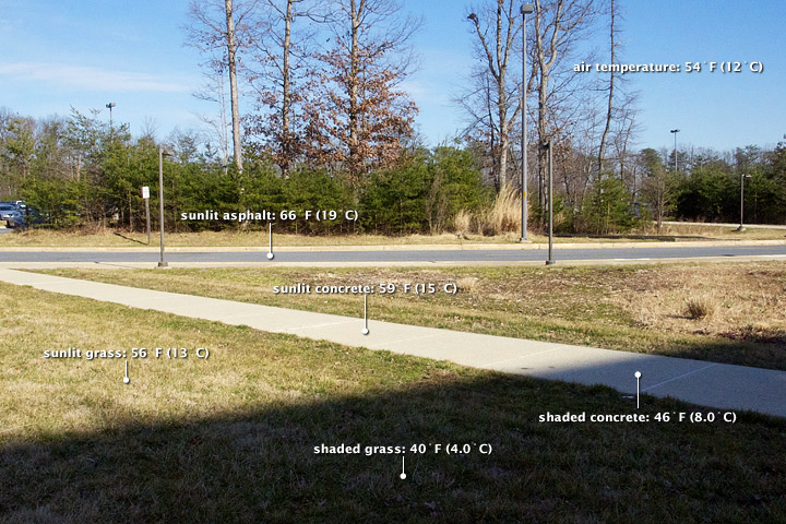
Direct sunlight can heat surfaces well above air temperature. On one late winter afternoon when the air was 54°F (12°C), shaded areas ranged from 40–46°F (4.0–8.0°C), while sunny spots were from 56–66°F (13–19°C). (NASA photograph by Robert Simmon.)
Air temperatures must be measured out of direct sunlight because the materials in and around the thermometer can absorb radiation and affect the sensing of heat. You feel this with your own body: if you stand in direct sunlight, you feel warmer because your skin is being heated by both the air and by the radiant energy from the Sun.
To make an air temperature reading according to the World Meteorological Organization standard (PDF), a thermometer must be situated 1.2 to 2 meters off the ground and shielded from direct sun—though it cannot be placed in the shade of a building, mountain, or tree either.
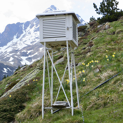
Accurate air temperature readings must be taken with thermometers that are carefully shielded from direct sunlight. (Photograph ©2006 Richard Allaway.)
MODIS measures something different: land skin temperature. LST is a measure of heating of the land surface—where solar energy is absorbed and re-emitted—and it is often significantly hotter than air temperature. If you’ve ever walked barefoot across hot sand or pavement on a summer day, you know the difference. The surface beneath your feet feels much hotter than the air around your head.
Scientists first measured that difference in June 1915. “Around the same time that the Death Valley record air temperature was measured, an analysis of the temperature conditions of air and soil was conducted in the desert near Tucson, Arizona,” Mildrexler explains. In the midday sun, the temperature 0.4 centimeters below the soil surface was 71.5°C (160.7°F). The air temperature, measured four feet above the ground, was 42.5°C (108.5°F).
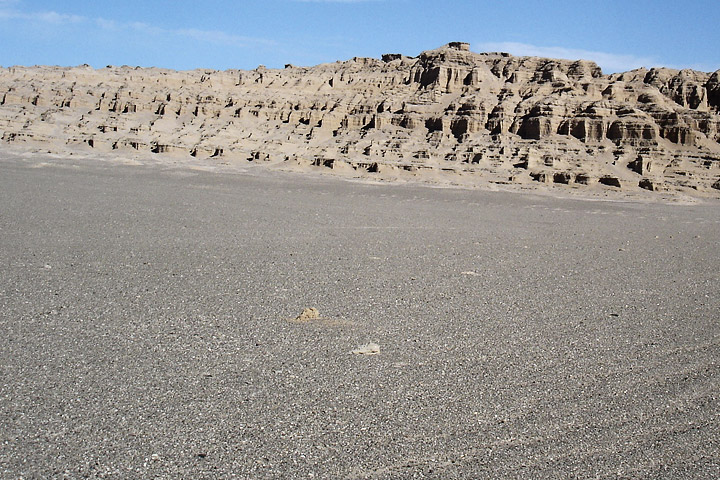
Dark pebbles help make Iran’s Lut Desert the hottest place on Earth. (Photograph ©2005 Jafar Sabouri, Geological Survey of Iran.)
Air temperatures, on the one hand, are moderated by circulation—both the rising and sinking of air masses into the atmosphere, and the horizontal movement of winds across the landscape. Moisture also regulates how much heat can be stored in the air. “The value of the air temperature measurement, as opposed to land surface temperature, is that it is what the human body, a building, or an ecosystem are feeling,” says Stuart Gaffin, a climate researcher at Columbia University and NASA’s Goddard Institute for Space Studies. “Air temperatures largely dictate our thermal comfort level.”
On the other hand, land skin temperatures reflect the pure heating of a parcel of ground by radiation from the sun, the atmosphere, and other heat flows. Therefore, the hottest LSTs are likely to occur where the skies are clear, the soil is dry, and the winds are light. The final ingredient is the composition of the land surface. It should absorb most light and reflect little—that is, have a low albedo—and it should not conduct heat very well. Rocky deserts offer the perfect combination.
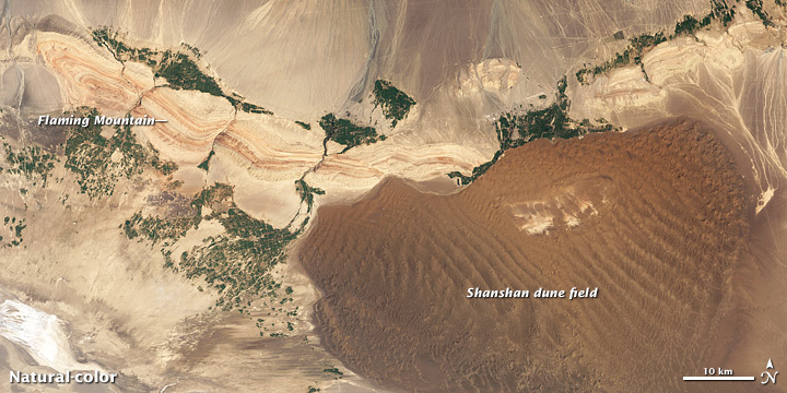
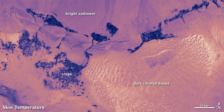
The dark surface of the Shanshan dune field absorbs sunlight more strongly than the adjacent Flaming Mountain, making it much hotter. (NASA images by Jesse Allen and Robert Simmon, using Landsat 7 data from the USGS Global Visualization Viewer.)
In their analysis, Running, Mildrexler, and Maosheng Zhao scrutinized global MODIS measurements of LST from 2003 to 2009, paying special attention to where the hottest satellite temperatures matched up with the ideal terrain. “To reveal the hottest spot on Earth,” Mildrexler notes, “we focused on barren areas and sparsely vegetated, open shrublands.”
The formula brought them to the Lut Desert in Iran. And to the badlands of Queensland, Australia. And to the Flaming Mountain.
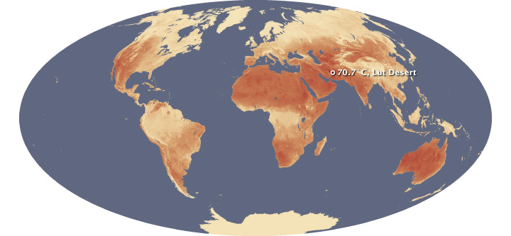
Seven years of satellite temperature data show that the Lut Desert in Iran is the hottest spot on Earth. The Lut Desert was hottest during 5 of the 7 years, and had the highest temperature overall: 70.7°C (159.3°F) in 2005. (NASA maps by Jesse Allen and Robert Simmon, using MODIS data from Mildrexler et al., 2011.
In five of the seven years—2004, 2005, 2006, 2007, and 2009—the highest surface temperature on Earth was found in the Lut Desert. The single highest LST recorded in any year, in any region, occurred there in 2005, when MODIS recorded a temperature of 70.7°C (159.3°F)—more than 12°C (22°F) warmer than the official air temperature record from Libya.
But the Lut was not the hottest spot every year. In 2003, the satellites recorded a temperature of 69.3°C (156.7°F)—the second highest in the seven-year analysis—in the shrublands of Queensland. And in 2008, the Flaming Mountain got its due, with a yearly maximum temperature of 66.8°C (152.2°F) recorded in the nearby Turpan Basin.
Researchers aren’t just interested in land surface heating for the trivia. Land surface temperatures are directly related to human development of the land.
“The hottest temperatures were observed at locations without vegetation,” writes climatologist Roger Pielke Sr. of the Cooperative Institute for Research in Environmental Sciences at the University of Colorado. “This means that if landscape change in a region results in less vegetation, the maximum surface temperatures are expected to be hotter. If an oasis is developed by irrigation from subsurface water in a desert, the maximum temperatures would be less.”
For a case study, Running, Mildrexler, and Zhao took an intensive look at the Pacific Northwest of the United States. “In the Pacific Northwest, there is a spectacular ecological gradient of biomes and temperatures from coast to rainforest to desert within a few hundred miles,” says Running. It is a near-perfect location to demonstrate how land cover relates the capacity of the surface to absorb and radiate heat.
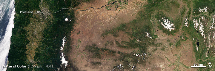
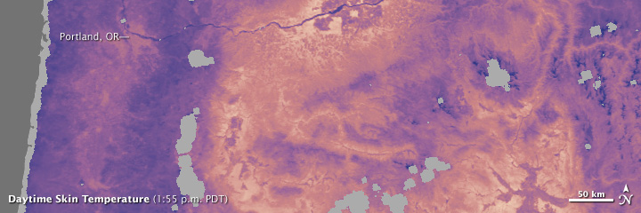
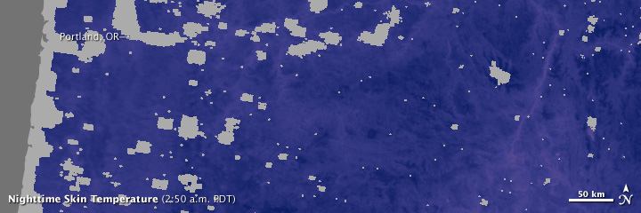
Satellite images show the relationship between the characteristics of a landscape, and day and night surface skin temperature. Heavily forested areas remain relatively cool throughout the day, while barren and arid areas can be tens of degrees warmer. These images were acquired in the early morning and afternoon of July 6, 2011. (NASA images by Jesse Allen and Robert Simmon, using MODIS data.)
In densely forested areas near the coast, land surface temperatures and air temperatures are a close match because trees can use their deep root systems to access soil moisture and cool themselves through evaporation (a process called transpiration). But move east into the farmland and grassland—where there is less soil moisture during the hottest times of year and the plants have much shallower roots—and the temperature readings start to diverge. Finally, the rocky inland deserts heat up spectacularly compared to the coast; they also cool spectacularly at night.
Mildrexler and Running see long-term records of LSTs as a potential tool for monitoring land cover change, particularly through deforestation, urban sprawl, and agricultural irrigation. Put simply: if skin temperatures are rising or falling over time, it could be an indication of a change in land use.
“During the highest temperatures of the year, forests are much cooler than cleared land, so if a forest is cut down, the land surface temperature will go up,” they wrote in 2011 in the Bulletin of the American Meteorological Society. “This can be seen in the Amazon. In other locations, irrigated crops are cooler than natural vegetation because they have more water to draw upon, and cool themselves through evaporation.”
But LSTs also reveal a lot about our increasingly urban life. As Stuart Gaffin notes: “I see surface temperatures in the city that routinely exceed what you might find in the desert.”
Gaffin studies the urban heat island effect—the propensity of cities to trap heat and grow considerably warmer than the surrounding natural environment. According to the U.S. Environmental Protection Agency, an urban area will often see air temperatures up to 6°C (10°F) hotter than the surrounding suburban and rural areas.
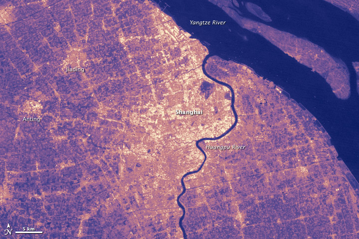
Cities are often much warmer than the surrounding landscape. This effect, called the urban heat island, is caused by removal of vegetation and construction of dark surfaces, like asphalt pavement and tar-paper roofs. (Map by Jesse Allen and Robert Simmon, using Landsat 7 data from the USGS Global Visualization Viewer.)
The resolution of most satellite sensors— the area depicted within each pixel of an image—is too coarse to observe LSTs in the tight and variable confines of a city. In the University of Montana study, for instance, the LST data had a spatial resolution of approximately 5.6 square kilometers. When viewed through a pixel of that size, cities contain a lot of shadows from buildings and vegetation that result in lower LSTs compared to a uniformly hot desert.
So Gaffin uses portable infrared radiometers—similar to the MODIS instruments—to measure surface temperatures in New York City. They have observed LSTs on the black tar-paper rooftops of the city between 77 to 82°C (170 to 180°F) in mid-summer, amplifying the oppressiveness of summer by radiating extra heat both by day and at night. Even in winter, rooftop temperatures can be tens of degrees warmer than local air temperatures.
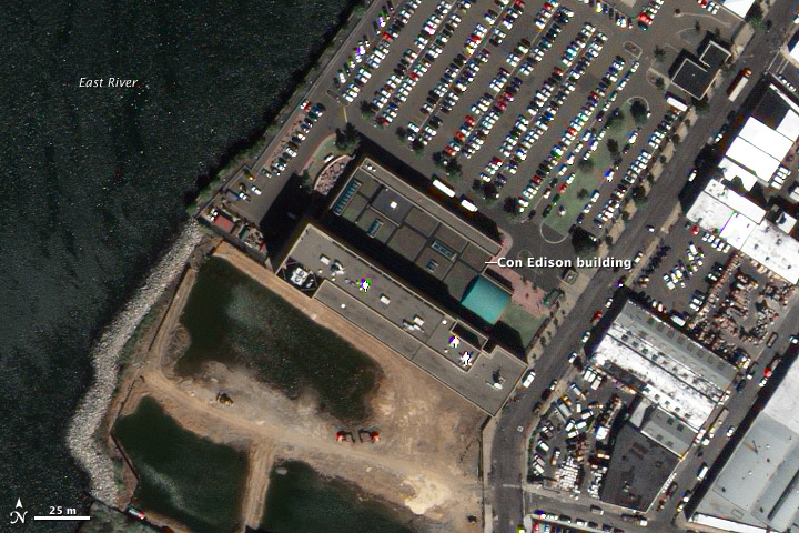

Temperatures in cities can rival the hottest desert. Using sensors installed at the Con Edison building in Queens, NY, scientists compare the surface temperature of black, white, and “green” (vegetated) roofs. The black roof can be up to 30°C (54°F) hotter than a green or white roof. (Images by Robert Simmon, using data ©2010 DigitalGlobe (image) and from the Columbia University Center for Climate Systems Research (graph).)
Gaffin is particularly interested in how rooftops and other flat, impervious surfaces concentrate heat, and in how they can be made to reflect more. The city has more than 77 square kilometers (30 square miles) of roof space that qualifies as “tar beaches.” It also has been blooming with new synthetic grass fields that mimic real grass and soil in dark color and texture, but don’t mimic the most important quality: the capacity to store and release water. Synthetic fields are like deserts in the city, with no moisture to cool the surface, so temperatures on these fields can approach the skin-burning levels of black pavement.
Gaffin and colleagues have been working for nearly a decade to find creative solutions to reduce heat island effects and LSTs in cities, such as resurfacing rooftops with white paint or with low-maintenance, lightweight vegetation. It is a matter of energy conservation and of quality of life. Rising LSTs lead to higher air temperatures, and a city that cooks itself through heat absorption has to spend more money and energy to cool itself.
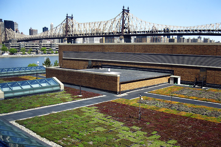
Although installing a green, plant-covered roof is the ultimate technique to combat urban heat, even a simple step like painting black roofs white can reduce temperatures dramatically. This photograph shows the green roof and instrumentation on top of the Queens Con Edison building. (Photograph ©2008 Con Edison of New York.)
“About 3.5 billion people now live in cities,” Gaffin notes. “We have two forces—urban heat islands and global warming—that are reinforcing each other and are going to create periodic, extreme conditions for more than half the world’s population. How do we make cities more habitable in the future?”