If you have ever walked along the California coast, you’ve likely had to navigate around clumps of seaweed. Fathom this: before it was thrown up by the surf and left to dry on the beach, that seeming jetsam was part of a majestic underwater forest just offshore.
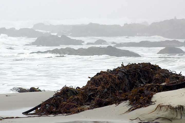
Strong waves, often fueled by winter storms, can remove large patches of offshore kelp and deposit them on the beaches of California. (Photo courtesy of Chad King / NOAA MBNMS)
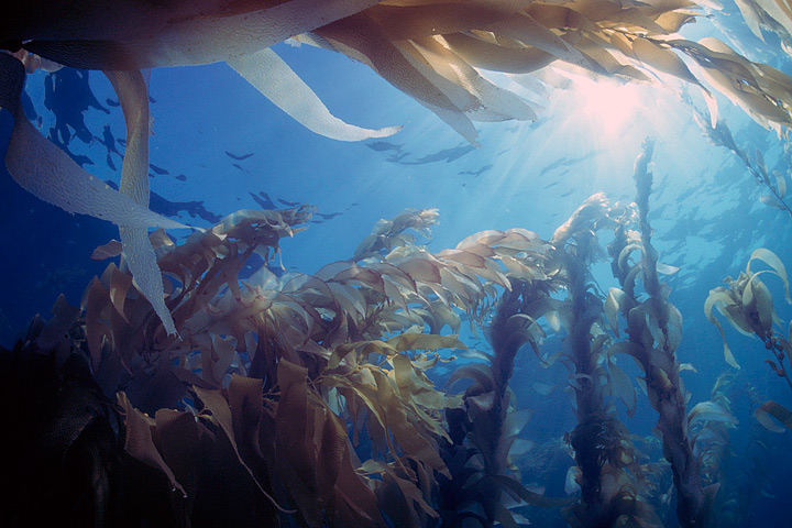
Giant kelp forests are among Earth’s most productive habitats, and their great diversity of plant and animal species supports many fisheries around the world. The kelp, or Macrocystis, that make up these underwater forests truly are giant. They are the world’s largest marine plants and regularly grow up to 35 meters (115 feet) tall; the largest giant kelp on record stood 65 meters (215 feet) tall. Divers have compared swimming through mature kelp forests to walking through redwood forests.
Unlike redwoods, giant kelp are ephemeral. They live for seven years at most, and often they disappear before that because of winter storms or over-grazing by other species. As fishermen know, giant kelp forests can appear and disappear from season to season, from year to year. But is there a long-term trend or cycle at work?
A few years ago, Jarrett Byrnes was in a bit of a quandary over these disappearing forests. As part of his postdoctoral research at the University of California–Santa Barbara (UCSB), he was studying giant kelp at four National Science Foundation-funded sites off the coast. Since 2000, biologists had been using this Long-Term Ecological Research (LTER) site to make monthly in situ measurements of giant kelp. But Byrnes and his colleagues found that they often could not make measurements in winter because rough seas made the diving unsafe.
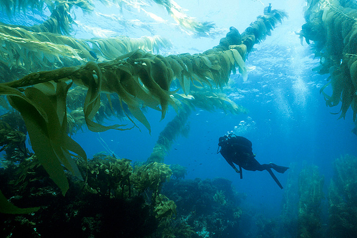
Kelp are the redwoods of the sea. The world’s largest marine plants regularly grow up to 35 meters (115 feet) tall. (Photograph © Phillip Colla / Oceanlight.com)
“Storms remove quite a bit of the canopy in the winter. Sometimes they even remove whole forests if the storms are large enough,” Byrnes explained. “But getting to those sites with regularity in the winter gets very challenging.” Most of the diving had to wait until summer, and by then the kelp had largely recovered or changed, making it difficult to measure how much damage the storms had done.
To complicate matters, kelp forests have different seasonality depending on where they are. For instance, the forests along the Central California coast are at their maximum size in the fall; in Southern California, they often reach their peak in the winter and spring. How could these dynamic habitats be monitored more frequently without putting divers at risk?
Kyle Cavanaugh, then a UCSB graduate student, had an idea. “These forests change so rapidly and on a variety of different time scales—months to years to decades—so we needed a long record with consistent, repeated observations,” Cavanaugh said. He devised a method to use Landsat satellite data to monitor kelp forests.
A few things made Landsat an obvious resource. Since the 1970s, the satellites have had a regular collection schedule (twice monthly). Their data and images are managed by the U.S. Geological Survey and are reliably stored in an archive that dates back more than forty years. And Landsat’s images are calibrated, or standardized, across different generations of satellites, making it possible to compare data collected across several decades.
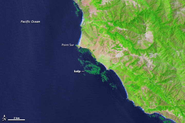
Landsat 8 can detect near-infrared wavelengths of light that make it easier to spot offshore kelp forests. (NASA Earth Observatory image by Mike Taylor, using Landsat data from the U.S. Geological Survey)
Landsat measures the energy reflected and emitted from Earth at many different wavelengths. By knowing how features on Earth reflect or absorb energy at certain wavelengths, scientists can map and measure changes to the surface. The most important feature for the kelp researchers is Landsat’s near-infrared band, which measures wavelengths of light that are just outside our visual range. Healthy vegetation strongly reflects near-infrared energy, so this band is often used in plant studies. Also, water absorbs a lot of near-infrared energy and reflects little, making the band particularly good for mapping boundaries between land and water.
“The near-infrared is key for identifying kelp from surrounding water,” Cavanaugh explained. “Like other types of photosynthesizing vegetation, giant kelp have high reflectance in the near infrared. This makes the kelp canopy really stand out from the surrounding water.”
For Byrnes, the approach was a breakthrough: “This meant we could see the forests I was analyzing right after storms hit them.”
Giant kelp are fast growers, and they thrive in cold, nutrient-dense waters, particularly where there is a rocky and shallow seafloor (5 to 30 meters or 15 to 100 feet). They attach to the seafloor with small root-like structures (haptera) also called, appropriately enough, a holdfast. The holdfast supports a stipe, or stalk, and leaf-like blades that float thanks to air-filled pockets (pneumatocysts). The fronds create dense floating canopies on the water surface, yet these massive plants rely on holdfasts barely 60 centimeters (24 inches) wide to keep them rooted and alive.
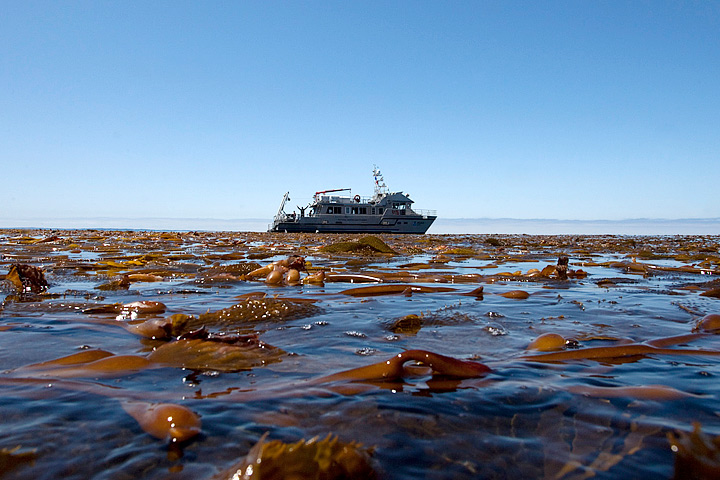
Given the right balance of conditions, giant kelp can grow as much as 50 centimeters (1.6 feet) per day, and this robust growth makes it possible for kelp fronds to be commercially harvested. Giant kelp have been plucked from California waters since the early 1900s, and they have long appeared in products like ice cream and toothpaste. At the industry’s peak, large ships using lawnmower-like machinery could harvest more than 200,000 wet tons annually.
Kelp fronds create dense floating canopies near the water surface. Kelp have been harvested for a century for commercial products; they also pose trouble for boat propellers. (Photo courtesy of Chad King / NOAA MBNMS)
“The satellite could definitely see the effects of harvesting, but the kelp recovery was very fast,” said Tom Bell, a UCSB researcher and collaborator with Byrnes and Cavanaugh.
Today, only a few thousand tons of giant kelp are harvested each year, some by hand and some by mechanical harvesters. The kelp can be trimmed no lower than 4 feet below the water surface, and this sustainable harvesting is the equivalent of humans getting a haircut. Studies have shown that negative affects are negligible, although some fish populations are temporarily displaced.
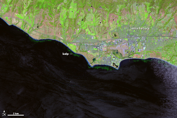
Giant kelp thrive in cold, nutrient-dense waters, particularly where there is a rocky, shallow seafloor. The California coast provides ideal habitat. (NASA Earth Observatory image by Mike Taylor, using Landsat data from the U.S. Geological Survey)
For years, scientists debated whether it was nutrient availability or grazers (not human harvesters, but sea urchins) that had the most influence over kelp forest health, size, and longevity. After using Landsat to look at long-term trends, and comparing those trends to known differences between Central and Southern California waters, Cavanaugh and LTER lead Daniel Reed found that a third force—wave disturbance—was the kingmaker of kelp dynamics. Strong waves generated by storms uproot the kelp from their holdfasts and can devastate the forests far more than any grazer.
When giant kelp first brought Byrnes and Cavanaugh together at UCSB, their work was largely California-focused. The data they collected from the LTER study sites off Santa Barbara became a tremendous resource for kelp researchers. But that work covered four discrete locations for a species found all over the world.
Giant kelp can grow anywhere there are cold, shallow, nutrient-rich waters and a rocky seafloor. Conditions for kelp growth have historically been ideal along the west coast of North America, as well as Chile, Peru, the Falkland Islands, South Africa, and around Australia, New Zealand, and the sub-Antarctic islands.
More and more often these days, though, the conditions are less ideal. Climate change has brought a trifecta of kelp scourges: warmer waters with fewer nutrients; new invasive species; and severe storms.
Given the right balance of conditions, giant kelp can grow as much as 50 centimeters (1.6 feet) per day. (Photograph © Phillip Colla / Oceanlight.com)
After a recent meeting on kelp forests and climate change, Byrnes, Cavanaugh, and other colleagues set out to consolidate all of the available kelp forest data from around the world. They wanted to take a step toward understanding how climate change is affecting kelp globally, but they quickly discovered they had a sparse patchwork of information.
Byrnes was struck with a thought. They had used Landsat to expand their studies across time, so why not use Landsat to expand their studies around the world? Could Landsat be used to establish global trends in kelp forest extent? The answer was yes, but the problem was eyeballs.
Unlike research on terrestrial vegetation—which uses Landsat data and powerful computer processing arrays to make worldwide calculations—distinguishing kelp forests requires manual interpretation. While kelp forests pop out to the human eye in near-infrared imagery, computers looking at the data numerically can confuse kelp patches with land vegetation. Programs and coded logic that separate aquatic vegetation from land vegetation can be confounded by things like clouds, sunglint, and sea foam.
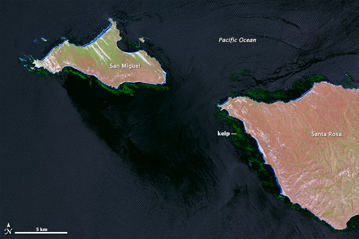
Natural color (top) and near-infrared (bottom) images from Landsat 8 show the kelp-rich waters around California’s Channel Islands. Clouds, sunglint, and sea foam make it difficult for computer programs to detect the location of forests. So far, human eyes work better. (NASA Earth Observatory image by Mike Taylor and Jesse Allen, using Landsat data from the U.S. Geological Survey)
“I’ve spent many, many years staring at satellite imagery trying to come up with new ways to extract the kelp signal from that imagery, and it is very time and work intensive,” said Cavanaugh, now based at the University of California–Los Angeles. “But automated classification methods just don’t produce acceptable levels of accuracy yet.”
Byrnes, now based at the University of Massachusetts–Boston, realized that the best way to study global kelp changes was to turn to citizen scientists. Byrnes and Cavanaugh put together a science team and joined with Zooniverse, a group that connects professional scientists with citizen scientists in order to help analyze large amounts of data. The result was the Floating Forests project.
The Floating Forest concept is all about getting more eyeballs on Landsat imagery. Citizen scientists—recruited via the Internet—are instructed in how to hunt for giant kelp in satellite imagery. They are then given Landsat images and asked to outline any giant kelp patches that they find. Their findings are crosschecked with those from other citizen scientists and then passed to the science team for verification. The size and location of these forests are catalogued and used to study global kelp trends.
In addition to examining the California coast, which Byrnes and Cavanaugh know well, the Floating Forests project has also focused on the waters around Tasmania. Tom Bell and collaborators in Australia and New Zealand have noticed dramatic declines in giant kelp forests there over the past few decades. The decline has been so rapid and extensive that giant kelp are only found now in isolated patches.
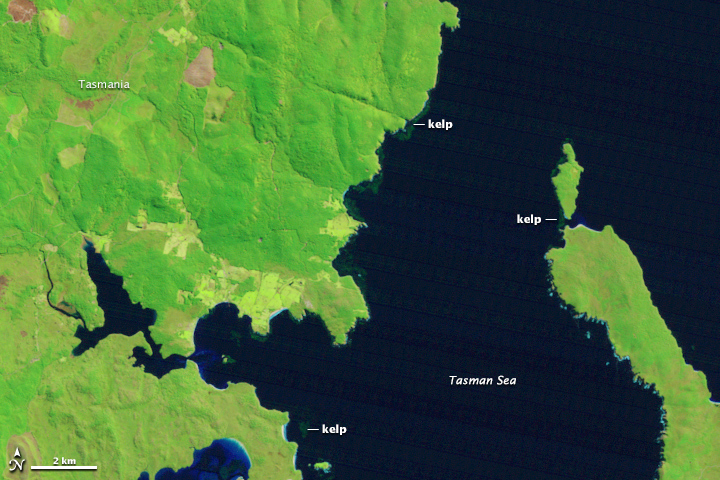
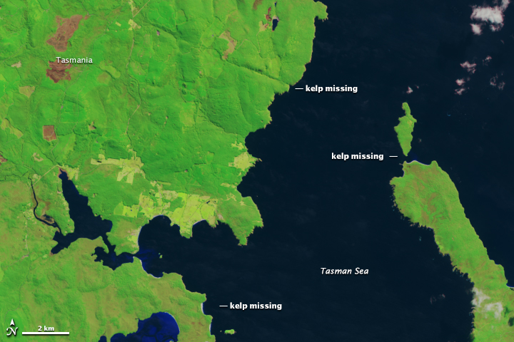
Off the east coast of Tasmania, 95 percent of the kelp has disappeared since the 1940s. False-color Landsat images from September 1999 (top) and September 2014 (bottom) provide evidence of recent kelp forest disturbance. (NASA Earth Observatory image by Mike Taylor, using Landsat data from the U.S. Geological Survey)
Off Tasmania’s east coast, 95 percent of the kelp has disappeared since the 1940s. The loss has been so stark that the Australian government listed Tasmania’s giant kelp forests as an “endangered ecological community“— the first time the country has given protection to an entire ecological community. The loss is so stunning because this was a place where kelp forests were once so dense that they merited mention on nautical charts.
Cool, subarctic waters once bathed Tasmania’s east coast, but warmer waters (as much as 2.5ºC (4.3ºF) warmer) have brought many invasive species that feast on giant kelp. Compounding the matter, the overfishing of rock lobsters has removed a key predator of the long-spined sea urchins (which eat kelp). The ecosystem’s new protected status could help curb overfishing and restore the lobsters, which would help diminish the threat from sea urchins.
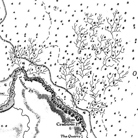
This U.S. Hydrographic Service chart from 1925 shows Prosser Bay, Tasmania, and the distribution of giant kelp. (Source: Edyvane at al, 2003)
Using Landsat to monitor the kelp forests and establish trends may shed more light on what is happening off of Tasmania. “We believe the data from Floating Forests will allow us to better understand the causes of these declines,” said Cavanaugh.
As of November 2014, more than 2,700 citizen scientists had joined Byrnes and Cavanaugh to look for kelp in 260,000 Landsat images. All combined, the citizen scientists have now made more than one million kelp classifications. The response has exceeded expectations, and the project has been expanded faster than originally planned.
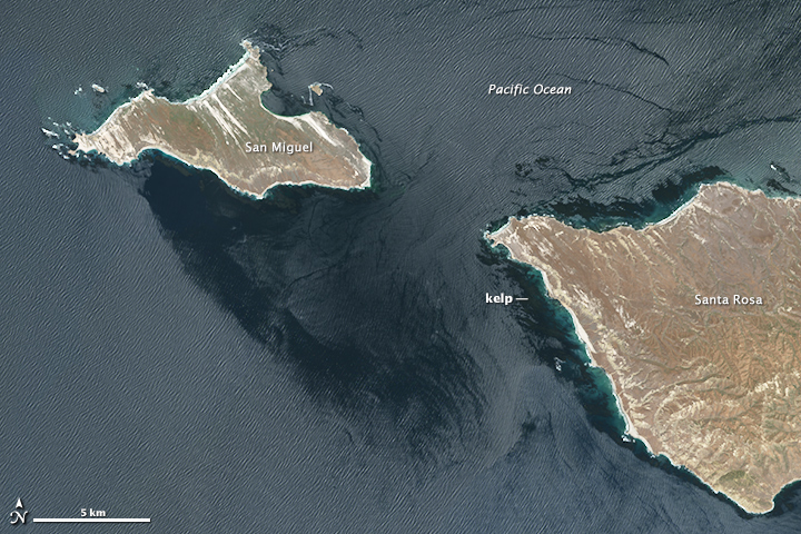
Already a discovery has been made. A citizen scientist found a large patch of giant kelp on the Cortez Bank, an underwater seamount about 160 kilometers (100 miles) off the coast of San Diego. While giant kelp on this submerged island—which comes within feet of the surface at some points—had been documented by divers and fishermen in the past, the full extent of the kelp beds was unknown.
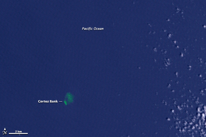
A citizen scientist found satellite evidence of an outlying kelp forest that was previously known only to divers and local fishermen. (NASA Earth Observatory image by Mike Taylor, using Landsat data from the U.S. Geological Survey)
“The first few months of Floating Forests have been a huge success, and we are hopeful that we will soon be able to expand the project to other regions,” Cavanaugh said. “Our ultimate goal is to cover all the coastlines of the world that support giant kelp forests.”
To learn how to participate in the Floating Forests project, visit their web page.
