 | |||
To an observer in space, humanity’s footprints on the surface of the Earth are large and varied. They include the regular patterns of irrigated cropland, straight lines of roads and railways running across continents, reservoirs on river systems, and the cement rectangles of ports and seawalls along coastlines. But what about humanity’s signature footprint—cities? By day, cities viewed from space can blend into the countryside, or appear as gray smudges, depending on the style of development and size of the urban area. |
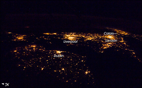
Looking east from a location southwest of Ireland, an astronaut took this nighttime panorama of population centers in Ireland and the United Kingdom. Image ISS016-E-27034 was taken on February 1, 2008, using a 28 mm lens. | ||
 | |||
At night however, city lights present the space observer spectacular evidence of our existence, our distribution, and our ability to change our environment. A few years ago, NASA and NOAA joined forces to present the first world map of the nighttime Earth using 9 months of data collected by the DMSP (Defense Meteorological Satellite Program) satellite from an altitude of 830 kilometers (1 kilometer is 0.62 miles) above Earth. That “Night Lights” map, widely distributed on the Internet, helped many people visualize the world’s distribution of people and cities. Astronauts circling the Earth have the wonderful vantage point of observing the nighttime Earth from 350-400 kilometers above the surface, taking in whole regions at once. Onboard cameras and a bit of experimentation allow astronauts to take highly detailed images of our cities at night and share them with the rest of us. |
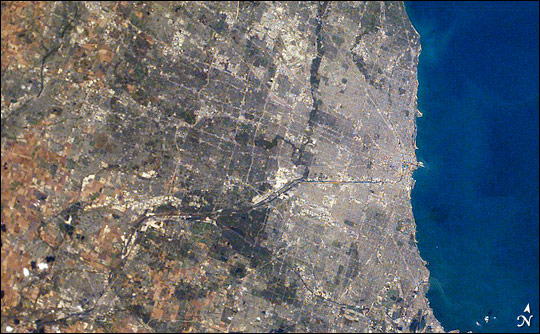
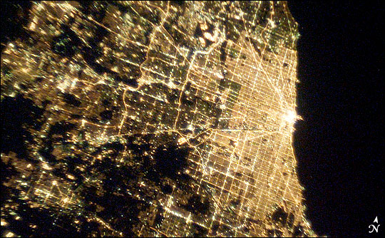
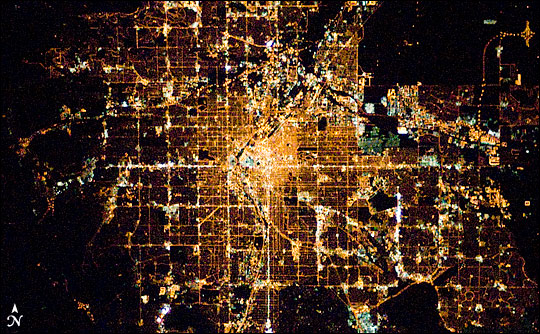
Chicago, Illinois, is home to roughly three million people, but the wider metropolitan area includes nearly 10 million. By day (top), the cement-colored urban center of the city blends almost imperceptibly into the gray-green colors of suburbs and then farmland. By night (lower), the region’s ten million people cannot be missed. ISS007-E-16747 (top) was taken on October 8, 2003, with a 50 mm lens. ISS007-E-16525 (bottom) was taken on October 7, 2003, with a 50 mm lens. | ||
 | |||
But taking pictures in the dark is difficult at best, made even more difficult by the fact that the International Space Station moves more than 7 kilometers per second (15,659 miles per hour) relative to Earth’s surface. With daylight illumination, an onboard camera can be set to take an image with an exposure time of just 1/500 of a second. With the Earth’s surface in darkness, night images of cities require much longer exposure times. As the Space Station (or Space Shuttle) flies over Earth, however, the city the astronaut is trying to photograph will move across the camera’s field of view while the shutter is open—a recipe for blurry images. The longer the exposure, the more motion blurring there will be. |
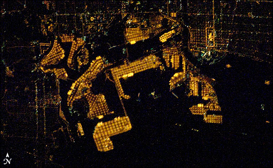
Orange sodium vapor lights illuminate the port facilities of Long Beach, California, supporting the round-the-clock operations of one of the world’s busiest commercial cargo ports. Image ISS016-E-27162 was taken on February 4, 2008, using the 400 mm lens, providing superior resolution. | ||
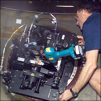
In late 2002 and early 2003, astronaut Don Pettit, part of International Space Station Expedition 6, spent some time accumulating spare parts from around the space station, and constructed a device called a barn-door tracker. A barn-door tracker is a camera mount commonly used by astronomers and photographers on the ground to capture images of stars and planets in the night sky. The camera is mounted on a hinged platform that can be moved very slowly and precisely (by turning a knob). On the ground, the device allows photographers to compensate for the rotation of the Earth relative to the stars. In space, it allows astronauts to compensate for the movement of the Space Station relative to the Earth below. The careful coordination keeps the targeted city in the same position in the camera’s field of view during the long exposure, even though both the station and Earth’s surface are moving. Pettit’s tracker and nighttime photography techniques produced hundreds of images of cities from around the world that had estimated resolutions (level of detail) of about 60 meters. Since then, a few other crew members have been able to successfully master night photography techniques. In late 2007 through early 2008, Expedition 16 Flight Engineer Dan Tani acquired a number of striking images of cities at night, including some exciting images taken with the longer, 400 mm lens, producing images with an estimated ground resolution of less than 10 meters. |
Don Pettit built and installed a “barn-door tracker” to enable him to take nighttime photographs from the International Space Station. Astronauts use the tracker to keep a camera steady during long exposures while the station moves above the Earth’s surface. Image ISS006-E-44299 was taken on April 5, 2003. | ||
 | |||
Recently, Don Pettit assembled a sequence of several of the most striking images of city lights at night into an animated “world tour.” This video (see below), produced entirely by Pettit, takes you on a quick trip comparing cities from different regions, all viewed from the International Space Station. |
Dan Tani, recently aboard the International Space Station as a member of Expedition 16, extended Don Pettit’s techniques for photographing city lights. He has taken nighttime photographs with a resolution of better than 10 meters (about the length of a bus) using a 400 mm lens. Image ISS016-E-026454 was taken on January 30, 2008. | ||
From a geographic perspective, cities at night tell different stories about a region. City lights provide sharp boundaries that delineate the densest concentrations of people, a characteristic that has been used to assess the effect of urbanization on Earth’s ecosystems. The increased detail of city lights available from astronaut photography can help refine urban boundaries defined from satellite data. Transportation corridors and major commercial development, such as ports, shopping centers, and cultural icons—like the Las Vegas strip—jump out of the landscape. |
Download this video in high-resolution (126 MB MPEG), web-resolution (39 MB QuickTime) or view the script. | ||
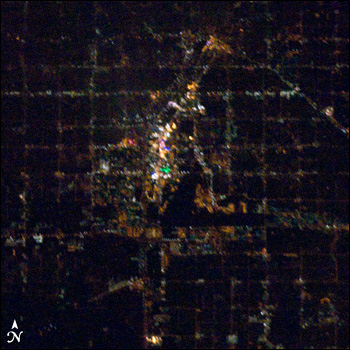
In many cities, neighborhoods of different generations can be distinguished by the lighting color and patterns along their streets. In many North American cities, older neighborhoods have less regular street patterns and light green mercury vapor lighting, while newer cities, especially in the western United States, have street patterns aligned to the compass directions and use orange sodium vapor lighting. The major Denver street patterns are rectilinear, aligned north-south and east-west. |
The “Vegas Strip” of casinos and hotels—reputed to be the brightest spot on Earth—stands out in the center of this image due to both its brightness and its diversity of light colors. Image ISS016-E-27168 was taken on February 4, 2008, using the 400 mm lens. | ||
 | |||
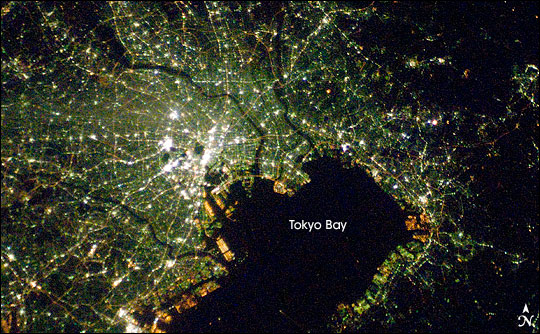
Cities from different regions of the Earth are also identified by differences in their nighttime lights. Japanese cities glow a cooler blue-green than other regions of the world. Newer developments along the shore of Tokyo Bay are characterized by orange sodium vapor lamps, while the majority of the urban area has light green mercury vapor lamps. |
The streets of Denver, Colorado, are aligned with the cardinal directions. Image ISS016-E-26150 was taken on January 31, 2008, with an 85 mm lens. | ||
 | |||
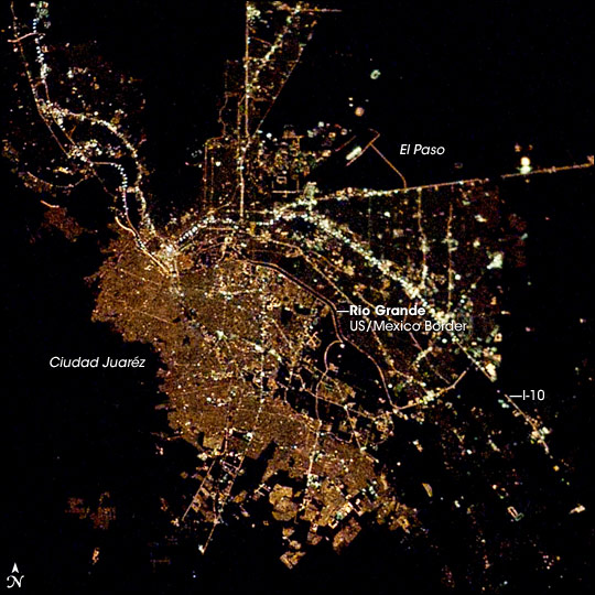
Border cities like Ciudad Juaréz, Mexico, and El Paso, Texas, illustrate different city patterns side-by-side, suggesting cultural influences on the development and growth of cities and infrastructure. Ciudad Juaréz, supports at least 1,300,000 people. On the U.S. side of the Rio Grande, El Paso is marked by the brightly-lit Interstate Highway I-10 that cuts across the city. Although the area of El Paso, with an estimated population of slightly more than 600,000 is roughly on the order of the area of built-up Ciudad Juaréz, the density of settlement evidenced by the distribution of lights, is much less. |
Like many Japanese cities, the night lights of Tokyo, Japan, have a blue-green glow that comes from mercury vapor lighting. Image ISS016-E-27586 was taken on February 5, 2008. | ||
 | |||
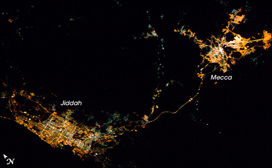
The rapid growth in Jiddah and Mecca in Saudi Arabia can be mapped from the lighting patterns, and the road connecting them stands out as a bright string in the surrounding dark desert. |
More densely populated Ciudad Juaréz, Mexico, is separated from El Paso, Texas, by the Rio Grande. Image ISS006-E-44123 was taken on April 7, 2003, with an 85 mm lens. | ||
 | |||
What’s next? Earth is becoming an urban planet. As more and more people move to cities, and the surrounding rural and suburban areas are increasingly developed, the pattern of lights in cities around the world will change. Individual city footprints will coalesce into ever larger bright blobs. More roads will connect those cities to form an illuminated, lace-like web on the habitable parts of the continents. Nighttime photographs from astronauts on upcoming missions will document these changes, providing dramatic illustrations for the continuing story of humanity’s footprints on the Earth. Astronaut photographs are provided by the ISS Crew Earth Observations experiment, and the Image Science & Analysis Laboratory, Johnson Space Center. The images in this article have been cropped and enhanced to improve contrast. Lens artifacts have been removed. The International Space Station Program supports the laboratory to help astronauts take pictures of Earth that will be of the greatest value to scientists and the public, and to make those images freely available on the Internet. Additional images taken by astronauts and cosmonauts can be viewed at the NASA/JSC Gateway to Astronaut Photography of Earth. Text and captions by Cynthia A. Evans and William L. Stefanov, NASA-JSC.
|
The cities of Jiddah and Mecca, Saudi Arabia, are connected by a well-lit pilgrim road. Image ISS016-E-16189 was taken on December 11, 2007, with an 85 mm lens. | ||
