
by Reto Stockli • October 13, 2005 Everyone knows that NASA studies space; fewer people know that NASA also studies Earth. Since the agency’s creation almost 50 years ago, NASA has been a world leader in space-based studies of our home planet. Our mission has always been to explore, to discover, and to understand the world in which we live from the unique vantage point of space, and to share our newly gained perspectives with the public. That spirit of sharing remains true today as NASA operates 18 of the most advanced Earth-observing satellites ever built, helping scientists make some of the most detailed observations ever made of our world. |
To access Blue Marble images in multiple resolutions, visit Visible Earth. |
||

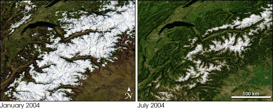
In celebration of the deployment of its Earth Observing System, NASA is pleased to share the newest in its series of stunning Earth images, affectionately named the “Blue Marble.” This new Earth imagery enhances the Blue Marble legacy by providing a detailed look at an entire year in the life of our planet. In sharing these Blue Marble images, NASA hopes the public will join with the agency in its continuing exploration of our world from the unique perspective of space. To learn more about the development of NASA’s imagery of the Earth as a whole, read the History of the Blue Marble. EnhancementsBlue Marble: Next Generation offers greater spatial detail of the surface and spans a longer data collection period than the original. The original Blue Marble was a composite of four months of MODIS observations with a spatial resolution (level of detail) of 1 square kilometer per pixel. Blue Marble: Next Generation offers a year’s worth of monthly composites at a spatial resolution of 500 meters. These monthly images reveal seasonal changes to the land surface: the green-up and dying-back of vegetation in temperate regions such as North America and Europe, dry and wet seasons in the tropics, and advancing and retreating Northern Hemisphere snow cover. From a computer processing standpoint, the major improvement is the development of a new technique for allowing the computer to automatically recognize and remove cloud-contaminated or otherwise bad data—a process that was previously done manually. |
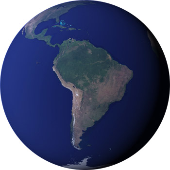
The Blue Marble: Next Generation is a series of images that show the color of the Earth’s surface for each month of 2004 at very high resolution (500 meters/pixel) at a global scale. This image shows South America from September 2004. (NASA image courtesy Reto Stöckli and Robert Simmon)
|
||

|
|||
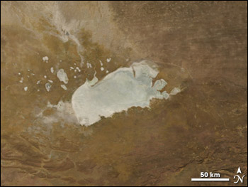
Blue Marble: Next Generation improves the techniques for turning satellite data into digital images. Among the key improvements is greater detail in areas that usually appear very dark to the satellite (because a large amount of sunlight is being absorbed), for example in dense tropical forests. The ability to create a digital image that provides great detail in darker regions without “washing out” brighter regions, like glaciers, snow-covered areas, and deserts is one of the great challenges of visualizing satellite data. The new version also improves image clarity, and gives highly reflective land surfaces, such as salt flats, a more realistic appearance. |
Monthly imagery shows seasonable variability, like the change in Alpine snow-cover from January to July. (NASA images by Reto Stöckli)
|
||

LimitationsThose who intend to use the Blue Marble: Next Generation in their own publications or projects should be aware of areas that still require improvement. Areas of open water still show some “noise.” In tropical lowlands, cloud cover during the rainy season can be so extensive that obtaining a cloud-free view of every pixel of the area for a given month may not be possible. Deep oceans are not included in the source data; the creator of the Blue Marble uses a uniform blue color for deep ocean regions, and this value has not been completely blended with observations of shallow water in coastal areas. The lack of blending may, in some cases, make the transition between shallow coastal water and deep ocean appear unnatural. Finally, the data do not completely distinguish between snow and cloud cover in areas with short-term snow cover (less than three or four months). This problem may be resolved in the future through the use of a more sophisticated snow mask. Data AccessFull-resolution, subsetted, and reduced-resolution files are available as JPEG, PNG, and GeoTIFF via the Blue Marble Next Generation collection on NASA’s Visible Earth and through the NASA Earth Observations (NEO) archive. AnimationsSeasonal Landcover Change over Western Asia in 2004 Interactive viewersCreditsBlue Marble: Next Generation was produced by Reto Stöckli, NASA Earth Observatory (NASA Goddard Space Flight Center). See The Blue Marble Next Generation—A true color Earth dataset including seasonal dynamics from MODIS (880 kB PDF) for acknowledgments. Anyone using or republishing Blue Marble: Next Generation please credit “NASA Earth Observatory.” |
Improvements to the data-processing algorithms resulted in relatively noise-free images with few artifacts. Dry salt flats, such as the Etosha Pan in Namibia, rendered as water in the original Blue Marble, but are now accurately colored. (NASA images by Reto Stöckli.)
|
||