
 | |||
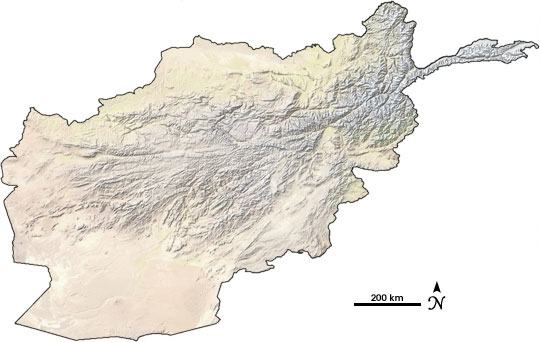
A glance at a map of Afghanistan reveals that it is a land of extremes. The rugged peaks of the Hindu Kush run down the spine of the country, flattening out into desert in the west. Rivers form thin blue lines that seep through the mountain valleys and venture across the arid landscape like arteries bringing life to the desert. The black dots of cities and towns cling to the blue lines, and vast voids fill the pockets between rivers. The harshness of the land alone makes living difficult, but political instability and violence and an extreme climate that flip-flops between prolonged drought and heavy snow, rain, and floods also pose serious challenges. |
|||
 | |||
From his office in Sioux Falls, South Dakota, Michael Budde is about as far away from Afghanistan as a person can get. Yet for him, it is more than a distant country on a map: the remote-sensing specialist is part of the Famine Early Warning System Network (FEWS NET), which works to avert famine, particularly in Africa, Central America, and Afghanistan. Set up by the U.S. Agency for International Development (USAID), FEWS NET issues warnings to governments and international aid organizations when drought or floods threaten food supplies, giving these organizations time to take preventative measures before suffering sets in. |
Afghanistan consists of rugged mountains with plains in the north and southwest. The country is mostly arid, with extreme temperatures in both winter and summer. (Natural Earth image courtesy Tom Patterson, U.S. National Park Service) | ||
“These problems are so enormous that there are a lot of times that you wonder if your work really makes a difference,” says Budde. In Afghanistan, for example, as much as 59 percent of the population suffers from chronic malnutrition. “It’s in very small, specific situations where the things you do have an impact,” Budde concludes. His involvement in Afghanistan began in 2002. “USAID wanted to know where to distribute spring wheat seed. They wanted a map that would tell them which provinces were best suited for the seed,” he recalls. He and his colleagues at FEWS NET responded by gathering satellite data and information from weather stations to track growing conditions in the mountainous country. Among the resources he turned to were satellite vegetation maps produced at NASA Goddard Space Flight Center. As FEWS NET began to monitor Afghanistan regularly, Budde also started to track water resources using snow maps created from data gathered by the Moderate Resolution Imaging Spectroradiometer on NASA’s Terra satellite. FEWS NET staff combine the NASA satellite data, weather and satellite information from the National Oceanic and Atmospheric Administration (NOAA) and the Air Force Weather Agency, and on-the-ground information in regular reports to the Afghan government. The reports, says Karim Rahimi, the former FEWS NET representative in Afghanistan, have become an important, reliable source of information for members of the Afghan Cabinet who need to know about food security in their country. |

In a 2002 visit to Afghanistan’s best children’s hospital, Congressman Joe Pitts discovered high mortality rates related to malnutrition. (Photo courtesy Congressman Joe Pitts) | ||