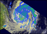
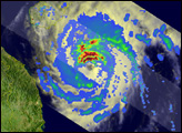
This image shows rainfall patterns in Typhoon Neoguri, the first typhoon of the 2008 season in the western Pacific Ocean, on April 17, 2008. The rain was most intense north of the storm’s eye, as indicated by bands of dark red. Green and blue bands show where lighter rain encircles the eye.
Published Apr 17, 2008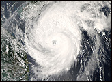
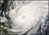
Typhoon Neoguri was nearing its peak strength on April 17, 2008, when the Moderate Resolution Imaging Spectroradiometer (MODIS) on NASA’s Aqua satellite captured this image at 1:30 p.m. local time (05:50 UTC). The first typhoon of the 2008 season in the western Pacific, Neoguri was a relatively weak Category 2 storm.
Published Apr 17, 2008