Atmosphere
Heat
Human Presence
Land
Life
Natural Events
All
Drought
Dust and Haze
Earthquakes
Fires
Floods
Landslides
Man-made
Sea and Lake Ice
Severe Storms
Temperature Extremes
Unique Imagery
Volcanoes
Water Color
Remote Sensing
Snow & Ice
Water
Collections
ABCs from Space
Air Quality
Amazon Deforestation
Applied Sciences
Astronaut Photography
Backgrounders
Blue Marble
Earth at Night
Earth from Afar
Fall Colors
Food and Agriculture
International Parks and UNESCO Sites
Renewable and Alternative Energy
Sea Level Rise
U.S. National Parks
World of Change
EO Explorer
Topics
Search
Images
Global Maps
Articles
Blogs
EO Explorer
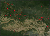
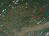
Fires in Para, Brazil
These images from the MODIS sensor on the Terra satellite on Nov. 18 and Dec. 7, 2004, show an area of deforestation and fires where the Tapajós River joins the Amazon River in western Pará, Brazil.
Image
Fires in Para, Brazil
Published Dec 9, 2004
Image of the Day
Heat
Land
Life
Fires
Image
Fires in Para, Brazil
Published Dec 8, 2004
Fires
Subscribe
To Our Newsletters
Receive notifications of our most recent images!
to our newsletters