Atmosphere
Heat
Human Presence
Land
Life
Natural Events
All
Drought
Dust and Haze
Earthquakes
Fires
Floods
Landslides
Man-made
Sea and Lake Ice
Severe Storms
Temperature Extremes
Unique Imagery
Volcanoes
Water Color
Remote Sensing
Snow & Ice
Water
Collections
ABCs from Space
Air Quality
Amazon Deforestation
Applied Sciences
Astronaut Photography
Backgrounders
Blue Marble
Earth at Night
Earth from Afar
Fall Colors
Food and Agriculture
International Parks and UNESCO Sites
Renewable and Alternative Energy
Sea Level Rise
U.S. National Parks
World of Change
EO Explorer
Topics
Search
Images
Global Maps
Articles
Blogs
EO Explorer
Widlfires and Haze over Borneo
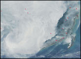
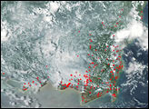
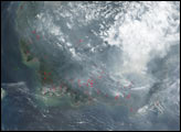
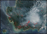
Haze from fires is thick over the Indonesian island of Borneo in late summer and fall 2002. Scores of wildfires (red dots) were detected by the Moderate Resolution Imaging Spectroradiometer instruments on the Terra and Aqua satellites.
Image
Widlfires and Haze over Borneo
Published Oct 24, 2002
Fires
Image
Widlfires and Haze over Borneo
Published Oct 18, 2002
Fires
Image
Widlfires and Haze over Borneo
Published Sep 1, 2002
Fires
Image
Widlfires and Haze over Borneo
Published Aug 20, 2002
Fires
Subscribe
To Our Newsletters
Receive notifications of our most recent images!
to our newsletters