Multiple layers of coal lie underground in ancient rocks. In some places, miners remove mountaintops to get at it.
Published Apr 10, 2011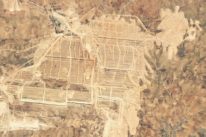
The mine is one of the few human patterns visible from space in this almost entirely uninhabited western extremity of the Sahara Desert.
Published Sep 23, 2018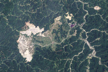
Landsat 5 observed the growth of one of the largest surface mines in the state it expanded from ridge to ridge.
Published Mar 3, 2010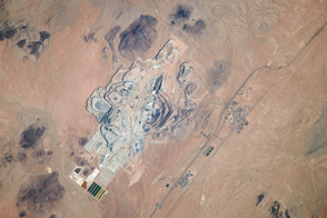
One of Earth’s richest borate deposits is at the center of the largest open-pit mine in California.
Published Nov 11, 2013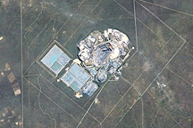
otswana ranks first among the world’s gem-quality diamond producers, and diamond mining makes up 70 percent of the nation’s export revenue. The Jwaneng Diamond Mine, in south-central Botswana, sits atop the convergence of three kimberlite pipes—diamond-rich geologic formations. Because the pipes meet just below the surface and cover some 520,000 square meters (128.5 acres) at ground level, the diamonds are mined from an open pit rather than a mine tunneled below the surface.
Published Oct 26, 2008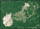
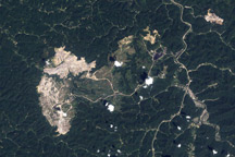
This pair of images shows the growth of a mountaintop removal in the headwaters of Mud River in Boone County, West Virginia, between 1987 and 2002.
Published Dec 23, 2007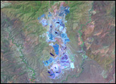
Located in the Sudirman Mountains of the Irian Jaya province of Indonesia, the Grasberg complex is one of the largest gold and copper mining operations in the world.
Published Aug 1, 2005
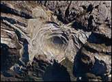
The pit near Phalaborwa and Kruger National Park is the most visible sign of a long history of mining in the region.
Published Jul 30, 2019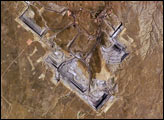
The United States’ highest rate of coal production is in Wyoming, with almost 4 million short tons extracted in 2004. The majority of this coal is burned to generate electrical power within the United States, but a small percentage is also goes to Spain and Canada. The Powder River Basin in the northeastern portion of the state is the most productive of Wyoming’s coal fields. The extensive coal deposits—ranging in thickness from 21 to 53 meters (70 to 175 feet)—formed over 38-66 million years ago. The source of organic material for the coal originated in swamps, estuaries, and deltas associated with the regression (retreat) of a large inland seaway that occupied central North America during the Cretaceous Period, which spanned the years between about 144 to 65 million years ago.
Published Oct 10, 2005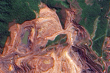
The terraced layers of red earth that make up the Carajás Iron Ore Mine contrast with the deep green Amazon Rainforest in this cloud-free image.
Published Jul 29, 2009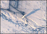
Snow and ice serve to accent human activities in this photograph taken by the Space Shuttle mission STS-98 crewmembers on February 17, 2001. The Souris River stretches across the photograph from left to right, with the upstream Rafferty Dam Reservoir frozen over on the far left. Two power plants, the Boundary Dam Power Station and the Shand Power Station, can be identified by the smoke plumes and shadows of those plumes. The river is frozen over upstream of the Boundary Dam Power Station, but thermal loading from the plants has warmed the water in the Boundary Dam Reservoir so that it remains nearly ice free. Downstream of the reservoirs, thermal loading is sufficient to maintain open flow in the Souris River.
Published Mar 18, 2001