
Floods and new infrastructure have long since separated the distinctive bend in the river that was portrayed by landscape painter Thomas Cole in 1836.
Published Oct 15, 2017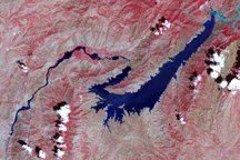
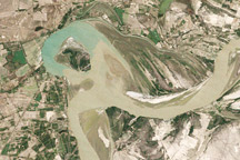
This false-color image shows the central part of the Vakhsh River, including the Nurek Dam and reservoir.
Published Nov 25, 2008
A satellite image offers inky evidence of the organic-rich freshwater that the Suwannee River delivers to the Gulf of Mexico.
Published Oct 27, 2018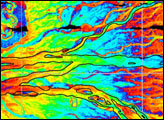
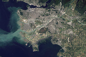
Flowing past the city of Vancouver, the Fraser River delivers a thick plume of sediment to the Strait of Georgia.
Published Mar 14, 2012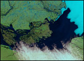
Between 1992 and 2009, a section of the lower Indus River changes course following the formation of an oxbow lake.
Published May 9, 2010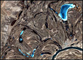
This false-color image from April 1, 2002, shows numerous braided channels and oxbow lakes along the Songhua River in northeastern China, just upstream of the city of Harbin.
Published Dec 27, 2005
Acquired April 2, 2011, and February 27, 2011, these natural-color images show rising waters on the Kuiseb River, which flowed all the way to the Atlantic Ocean for the first time in decades.
Published Apr 12, 2011
As they prepare for a satellite that will measure the height and areal extent of rivers in unprecedented detail, hydrologists have released a better map of North American river widths.
Published Jul 9, 2015
Acquired May 1, 2011, this natural-color image shows the James River completely filling the river valley near Jamesville, South Dakota.
Published May 3, 2011