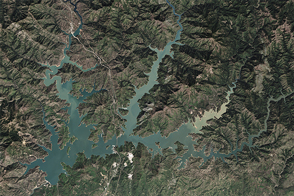
After four years of shrinking due to drought, the largest reservoir in California got a much-needed boost from El Niño-fueled winter precipitation.
Published Apr 7, 2016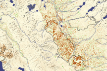
Dark brown squares mark fields that would ordinarily support irrigated crops in California’s Central Valley in this vegetation image. In 2009, a lack of water meant that the crops were not growing well or the fields lay fallow.
Published Aug 16, 2009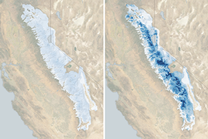
The water stored as snow in the 400-mile long range is now 185 percent of normal for the beginning of March.
Published Mar 3, 2017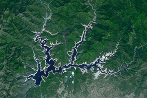
The Golden State’s largest reservoir has warmed and become depleted over the past decade.
Published Jun 26, 2015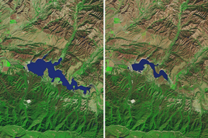
While autumn rains offered some relief to Northern California, drought still reigns in the southern part of the state.
Published Nov 16, 2016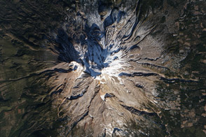
Mount Shasta is usually snow-capped. But this winter, it is a lot more brown than white, as drought deepens in California.
Published Jan 17, 2014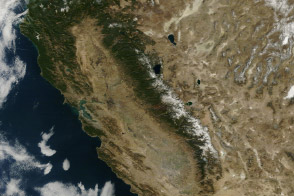
From brown landscapes to snow-free mountains, California was startlingly dry as a serious drought prompted a state of emergency.
Published Jan 23, 2014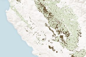
Analysis of Landsat and MODIS data showed where agricultural production was affected by long-term drought in California.
Published Jan 30, 2015
For more than 100 years, groups in the western United States have fought over water. During the 1880s, sheep ranchers and cattle ranchers argued over drinking water for their livestock on the high plains. In 1913, the city of Los Angeles began to draw water away from small agricultural communities in Owen Valley, leaving a dusty dry lake bed. In the late 1950s, construction of the Glen Canyon Dam catalyzed the American environmental movement. Today, farmers are fighting fishermen, environmentalists, and Native American tribes over the water in the Upper Klamath River Basin. The Landsat 7 satellite, launched by NASA and operated by the U.S. Geological Survey, documented an extreme drought in the area along the California/Oregon border in the spring of 2001.
Published Sep 8, 2001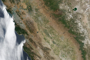
The typically green valleys and snow-covered mountains of California have grown dusty after three years of drought.
Published Jul 18, 2014