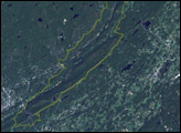
The park runs roughly 40 miles along the Delaware River and the Appalachian Mountains, which are immediately adjacent to the river.
Published Jan 9, 2005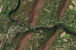
The scenic double water gap near Harpers Ferry has impressed onlookers for centuries.
Published Jan 17, 2017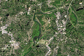
The river supplies Atlanta with its drinking water and a bit of recreational fun.
Published Nov 13, 2016
Natural vegetation and irrigated farmland along the Snake River Plain in Idaho use dramatically different amounts of water during the growing season.
Published Jan 26, 2010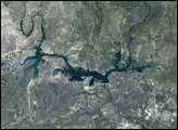
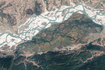
In the Indian state of Assam, Kaziranga National Park protects a few hundred square miles of the Brahmaputra River's floodplain.
Published Aug 2, 2010
An arid region grew even drier between 2003 and 2009 due to human consumption of water for drinking and agriculture.
Published Mar 13, 2013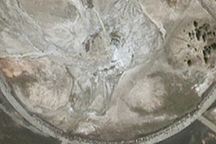
Yellowstone National Park’s Old Faithful Geyser erupts so reliably—every hour on the hour—you can set your watch by it. So goes the legend, but it’s not true.
Published Nov 30, 2008
For more than 100 years, groups in the western United States have fought over water. During the 1880s, sheep ranchers and cattle ranchers argued over drinking water for their livestock on the high plains. In 1913, the city of Los Angeles began to draw water away from small agricultural communities in Owen Valley, leaving a dusty dry lake bed. In the late 1950s, construction of the Glen Canyon Dam catalyzed the American environmental movement. Today, farmers are fighting fishermen, environmentalists, and Native American tribes over the water in the Upper Klamath River Basin. The Landsat 7 satellite, launched by NASA and operated by the U.S. Geological Survey, documented an extreme drought in the area along the California/Oregon border in the spring of 2001.
Published Sep 8, 2001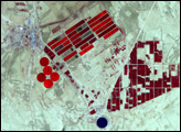
Management and restoration features are visible in Florida’s unique subtropical wilderness.
Published Nov 12, 2016