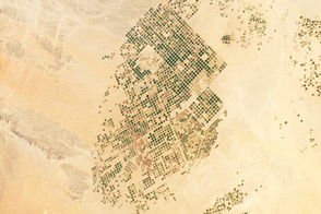
This photograph from the International Space Station presents an almost surreal view of abundant green fields in the midst of a barren desert.
Published Mar 5, 2012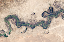
Acquired September 30, 2010, this astronaut photograph shows part of the Syr Darya River Floodplain in Kazakhstan, where the river flows through braided channels.
Published Nov 1, 2010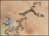
Green circles in the desert frequently indicate tracts of agriculture supported by center-pivot irrigation. The Al Khufrah Oasis in southeastern Libya (near the Egyptian border) is one of Libya’s largest agricultural projects, and is an easy-to-recognize landmark for orbiting astronauts aboard the International Space Station. Because only about 2 percent of Libya’s land receives enough rainfall to be cultivated, this project uses fossil water from a large underground aquifer. The Libyan government also has a plan called the Great Man Made River to pump and transport these groundwater reserves to the coast to support Libya’s growing population and industrial development.
Published Nov 15, 2004
The Shebelle River has its headwaters in the Ethiopian Highlands, and transports water and sediment 1,000 kilometers to the southeast across Ethiopia and into Somalia.
Published Apr 11, 2011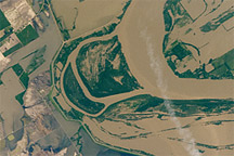
Taken May 12, 2011, this astronaut photograph shows flooding of the Mississippi River along the border between Tennessee and southeastern Missouri.
Published May 16, 2011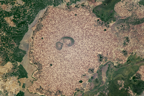
Standing beside floodplains and wetlands, the highlands are packed with farms.
Published Apr 3, 2017
Natural vegetation and irrigated farmland along the Snake River Plain in Idaho use dramatically different amounts of water during the growing season.
Published Jan 26, 2010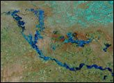
Water from the Kaidu River made it possible to turn part of the Taklamakan Desert into an oasis for agriculture, but it has also disturbed the water table.
Published Aug 18, 2012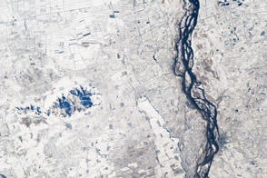
This astronaut photograph highlights hundreds of rectangular fields along the Songhua River in eastern China.
Published Dec 17, 2012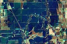
A pair of false-color and natural-color images acquired March 21, 2010, show flooding in agricultural areas north of Fargo, North Dakota.
Published Mar 24, 2010