Acquired on June 6, 2010, this natural-color image shows brightly hued waters in a network of salt marshes between the Black Sea and the Sea of Azov.
Published Nov 20, 2010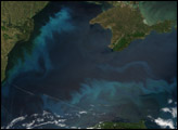
Phytoplankton and stirred up sediments deliver a splash of spring color to the Black Sea.
Published May 13, 2016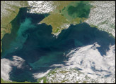
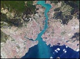
This metropolis of 15 million people occupies both sides of the entrance to the narrow, 20-mile long Bosporus Strait connecting the Mediterranean and Sea of Marmara (south) to the Black Sea (north). From its founding as Byzantium by the Greeks in 600 B.C., this strategically located city has been a focus of maritime trade and commerce as well as an outpost and threshold for cultural exchange and conflict between Europe and Asia. This digital camera image was taken by the crew of the International Space Station on April 16, 2004. When this image was taken, strong currents carried turbid coastal waters from the Black Sea through the Strait and into the Sea of Marmara.
Published May 10, 2004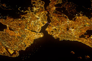
The cultural, economic, and historic heart of Turkey glows in the night.
Published Sep 10, 2012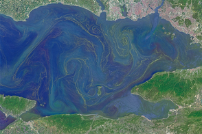
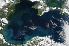
Freshened surface water and abundant nutrients lead to an explosion of algae in the inland sea.
Published May 31, 2015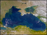
This cloud-free, Sea-viewing Wide Field-of-view Sensor (SeaWiFS) image of the Black Sea on June 9, 2003, reveals the colorful interplay of currents on the lake’s surface. The green crescent-shaped pattern in the northwestern corner of the Black Sea is due to the nutrient-rich, sediment-laden discharge of the Danube River stimulating biological activity. The brighter, more turquoise patterns on the lake to the south and east are probably blooms of another type of phytoplankton.
Published Jun 10, 2003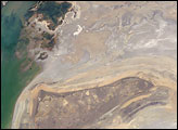
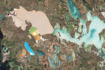
The arrow-shaped island in the Aral Sea used to be a 35-kilometer-long visual marker, indicating the Aral Sea to astronauts. An image from the present International Space Station increment shows how much the coastline has changed as the sea level has dropped during the last three decades.
Published Aug 15, 2005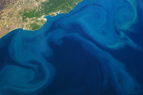
Rivers transport nutrient-filled urban and agricultural runoff into this inland sea, promoting phytoplankton blooms.
Published May 27, 2013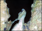
The lowest spot on dry land, the Dead Sea depression sinks 400 meters (1,300 feet) below sea level.
Published Nov 12, 2006