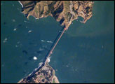
Astronauts aboard the International Space Station (ISS) took this photograph of the San Francisco Bay area in April, 2002. The gray urban footprint of San Francisco, Oakland, San Jose, and their surrounding suburbs contrast strongly with the green hillsides. Of particular note are the Pacific Ocean water patterns that are highlighted in the sun glint. Sets of internal waves traveling east impinge on the coastline south of San Francisco. At the same time, fresher bay water flows out from the bay beneath the Golden Gate Bridge, creating a large plume traveling westward. Tidal current channels suggest the tidal flow deep in thebay. Because the ISS orbits are not synchronous with the sun, astronauts view the Earth with variable solar illumination angles. This allows them to document phenomena such as the sun reflecting differentially off surface waters in a way that outlines complicated water structures.
Published May 26, 2002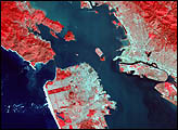
The Golden Gate of San Francisco Bay is one of the most recognizable straits in the world due to the Golden Gate Bridge that spans it. This high-resolution astronaut photograph is a nearly cloud-free view of the northern part of the San Francisco metropolitan area.
Published Sep 4, 2006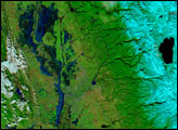
Northern California ushered in 2006 with a series of major storms that inundated the area and left many towns awash in water, mud, and debris. According to a report from the USATODAY.com Website, at least two levees in the Sacramento-San Joaquin Delta region were unable to handle the rising waters and strong winds, and residents nearby evacuated as the water-control structures began leaking. In the wine-country town of Napa perhaps as many as 1,000 homes were flooded along with thousands of acres of rural and agricultural land. The governor declared several counties in the region flood disaster areas.
Published Jan 6, 2006
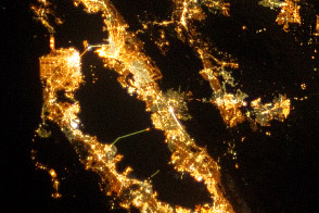
City lights reflect some of the landscape features that determine urban growth patterns in the region.
Published Oct 21, 2013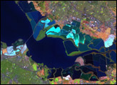
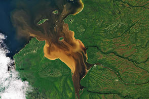
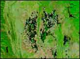
Dissolved organic matter from forests and wetlands stained the water dark brown near Rupert Bay. A similar process darkens tea.
Published Oct 1, 2016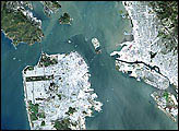

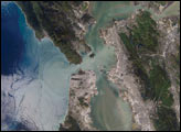
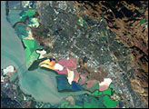
The red and green colors of the salt ponds in South San Francisco Bay are brilliant visual markers for astronauts. The STS-111 crew photographed the bay south of the San Mateo bridge in June, 2002.
Published Jul 21, 2002