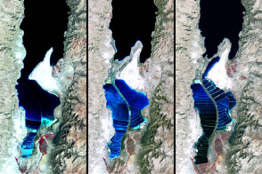
The lake between Israel and Jordan provides a bounty of salt and of history.
Published Apr 6, 2012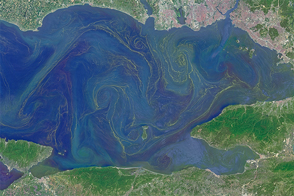
Freshened surface water and abundant nutrients lead to an explosion of algae in the inland sea.
Published May 31, 2015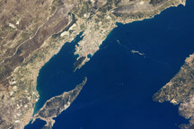
This astronaut photo from April 9, 2009, shows the Dalmatian coastline of the Adriatic Sea around Split, Croatia.
Published May 4, 2009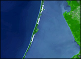
In the southeastern corner of the Baltic Sea lies a skinny stretch of land. Known as the Curonian (or Courland) Spit, it separates the Curonian Lagoon (also known as the Courland Lagoon) from the Baltic Sea. Both the spit and the lagoon fall within the borders of Lithuania and Russia’s Kaliningrad Oblast.
Published Nov 2, 2007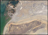
The arrow-shaped island in the Aral Sea used to be a 35-kilometer-long visual marker, indicating the Aral Sea to astronauts. An image from the present International Space Station increment shows how much the coastline has changed as the sea level has dropped during the last three decades.
Published Aug 15, 2005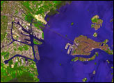
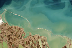
By analyzing satellite images of sediments, coastal researchers and cartographers can identify potential shallows, shoals, and shipping hazards.
Published Sep 17, 2015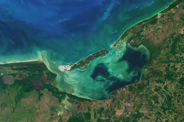
Mexico’s largest coastal lagoon supports an array of vegetation and marine life.
Published Sep 4, 2017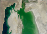
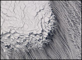
Tucked between Siberia and Russia's frozen Kamchatka Peninsula, the Sea of Okhotsk was a field of ice in February 2007.
Published Feb 8, 2007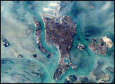
The compact Italian city of Venice with its renowned canals is situated on a small, fish-shaped island in the Laguna Veneta at the northwest corner of the Adriatic Sea. In this photo taken from the International Space Station by the Expedition 1 Crew on February 21, 2001, one can see part of the causeway connecting the city to the mainland. The sinuous Canal Grande bisecting the city is easily visible in this scene as is the larger Canal Giudecca to the west, which leads to the port facilities on the northwestern end of the island. For centuries, the low-lying city has successfully coped with the three-foot tidal range experienced at this end of the Adriatic Sea, and the series of barrier islands has offered some protection from storm waves. However, a combination of both regional land subsidence and recent slight rises in sea level pose a significant threat this historic city and its priceless art treasures.
Published Jul 8, 2001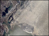
The Aral Sea has shrunk to less than half its size since 1985. It receives little water (sometimes none) from the two major rivers that empty into it—the Syr Darya and Amu Darya. Instead, the river water is diverted to support irrigation for the region’s extensive cotton fields. Recently, water scarcity has increased due to a prolonged drought in Central Asia. As the Aral Sea recedes, its former seabed is exposed. The Aral’s sea bed is composed of fine sediments—including fertilizers and other agricultural chemicals—that are easily picked up by the region’s strong winds, creating thick dust storms. The International Space Station crew observed and recorded a large dust storm blowing eastward from the Aral Sea in late June 2001. This image illustrates the strong coupling between human activities (water diversions and irrigation), and rapidly changing land, sea and atmospheric processes—the winds blow across the Sea and pick up dust (former sea bottom sediments) as soon as the blowing air masses hit land.
Published Dec 30, 2001