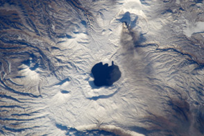
This astronaut photograph shows ash streaming from Karymsky Volcano, and nearby Karymsky Lake—the water-filled remnant of an ancient eruption.
Published Nov 26, 2012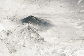
This photograph from the ISS highlights one of the most active volcanic regions on Earth: the Kamchatka Peninsula in far eastern Russia.
Published Jul 27, 2015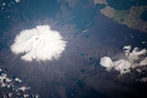
The largest and most active of several volcanic centers on New Zealand’s North Island is also the island’s highest mountain.
Published Oct 28, 2013
This photograph of snow-covered volcanoes on Russia’s Kamchatka Peninsula illustrates one of the unique attributes of the International Space Station—the ability to view landscapes at an angle, rather than the straight down view typical of many satellite-based sensors.
Published Dec 6, 2010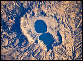
The approximately 4-kilometer-wide Dendi Caldera includes some of this silica-rich volcanic rock: the rim of the caldera, visible in this astronaut photograph, is mostly made of poorly consolidated ash erupted during the Tertiary Period (approximately 65–2 million years ago).
Published Mar 31, 2008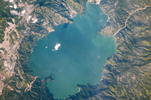
This astronaut photo shows the blue-green waters of Lake Ilopango, which fills the caldera of a volcano in El Salvador that last erupted in 1879.
Published Dec 14, 2009
Volcan Parinacota is a potentially active stratovolcano located on the Altiplano, a high plateau in the Andes mountains.
Published Oct 17, 2011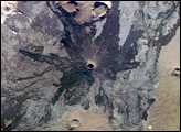
The western half of the Arabian Peninsula contains not only large expanses of sand and gravel, but extensive lava fields known as haraat. One such field is the 14,000-square-kilometer Harrat Khaybar, located approximately 137 kilometers to the northeast of the city of Al Madinah (Medina). The volcanic field was formed by eruptions along a 100-kilometer, north-south vent system over the past 5 million years. The most recent recorded eruption took place between 600–700 AD.
Published Apr 14, 2008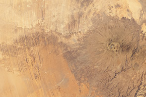
Two neighboring craters in Africa had very different origins.
Published Jan 9, 2012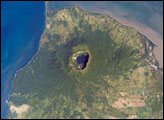
Three Central American countries—El Salvador, Honduras, and Nicaragua—have coastline along the Gulf of Fonseca, which opens into the Pacific Ocean. The southern boundary of the Gulf is a peninsula formed by the Cosigüina Volcano. Cosigüina is a stratovolcano, which is a cone-shaped volcano formed by alternating layers of solidified lava and volcanic rocks produced by explosive eruptions.
Published Dec 31, 2007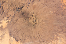
At 3,415 meters above sea level, the summit is the highest of Africa’s Sahara region.
Published Feb 14, 2011